Arizona State Route 261

Arizona State Route 261
Straßenschild der Arizona State Route 261
Karte
Karte der Arizona State Route 261
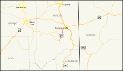
Basisdaten
Gesamtlänge:  17,92 mi/28,84 km
Anfangspunkt:  Arizona 273.svg AZ 273 am Crescent Lake
Endpunkt:  Arizona 260.svg AZ 260 westlich von Eagar
County:  Apache County

Die Arizona State Route 261 (kurz AZ 261) ist eine State Route im US-Bundesstaat Arizona, die in Nord-Süd-Richtung verläuft.

Die State Route beginnt an der Arizona State Route 273 am Crescent Lake und endet nach 29 Kilometern westlich von Eagar an der Arizona State Route 260. Nach etwa 16 Kilometern passiert die AZ 261 im Westen den Mexican Hay Lake. Die Straße verläuft durch den Apache-Sitgreaves National Forest und dient als Anbindung von Eagar und Springerville an die White Mountains sowie den Big Lake.

Siehe auch

Weblinks


Wikimedia Foundation.

Игры ⚽ Нужно сделать НИР?

Schlagen Sie auch in anderen Wörterbüchern nach:

  • Arizona State Route 261 — Infobox road marker state=AZ highway name= name notes= type=state route=261 alternate name= maint= length mi=17.92 length round=2 length ref=cite web |url=http://tpd.az.gov/data/reports/2006SHSLog.pdf |title=2006 ADOT Highway Log |author=Arizona… …   Wikipedia

  • Arizona State Route 273 — Karte …   Deutsch Wikipedia

  • Arizona State Route 260 — Basisdaten Gesamtlänge:  217 mi/350 km Anfangspunkt:  …   Deutsch Wikipedia

  • Arizona State Route 264 — Infobox road marker state=AZ highway name= name notes= type=state route=264 alternate name= maint= length mi=154.35 length round=2 length ref=cite web |url=http://tpd.az.gov/data/reports/2006SHSLog.pdf |title=2006 ADOT Highway Log |author=Arizona …   Wikipedia

  • Arizona State Route 273 — Infobox road marker state=AZ highway name= name notes= type=state route=273 alternate name= maint= length mi=19.26 length round=2 length ref=cite web |url=http://tpd.az.gov/data/reports/2006SHSLog.pdf |title=2006 ADOT Highway Log |author=Arizona… …   Wikipedia

  • Arizona State Route 260 — Infobox road marker state=AZ highway name= name notes= type=state route=260 alternate name= maint= length mi=217.78 length round=2 length ref=cite web |url=http://tpd.az.gov/data/reports/2006SHSLog.pdf |title=2006 ADOT Highway Log |author=Arizona …   Wikipedia

  • California State Route 60 — State Route 60 Route information …   Wikipedia

  • Interstate 210 and State Route 210 (California) — Interstate 210, State Route 210 Foothill Freeway …   Wikipedia

  • List of highways numbered 261 — The following highways are numbered 261: United States Alabama State Route 261 Arizona State Route 261 California State Route 261 …   Wikipedia

  • Liste der Highways in Arizona — Dies ist eine Aufstellung von State Routes, U.S. Highways und Interstates im US Bundesstaat Arizona, nach Nummern. Inhaltsverzeichnis 1 State Routes 1.1 Gegenwärtige Strecken 1.2 Geplante Strecken 1.3 Außer Die …   Deutsch Wikipedia

Share the article and excerpts

Direct link
Do a right-click on the link above
and select “Copy Link”