- Beacon Rock State Park
-
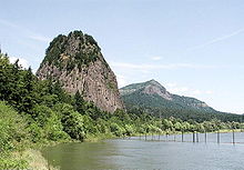 Beacon Rock
Beacon Rock State Park ist ein 20 Quadratkilometer großer State Park im US-Bundesstaat Washington. Der Park liegt am Nordufer des Columbia in der Columbia River Gorge. Der namensgebende Beacon Rock ist ein 258 Meter hoher Vulkanrest, dessen weichere Schichten von den eiszeitlichen Fluten des Columbia fortgespült wurden, so dass nur noch der Felsen am Ufer stehen blieb.
Inhaltsverzeichnis
Geschichte
Die Indianer bezeichnen den Felsen als Che-che-op-tin, als Nabel der Welt. Beacon Rock wurde der Felsen zuerst von den Teilnehmern der Lewis-und-Clark-Expedition am 31. Oktober 1805 benannt. Hier bemerkten sie erstmals den Einfluss der Gezeiten des Pazifiks im Columbia River. 1811 benannte Alexander Ross, ein Pelzhändler im Dienst der Pacific Fur Company von John Jacob Astor, den Felsen Inoshoack Castle. Diesen Namen behielt er, bis das United States Board of Geographic Names den Felsen wieder in Beacon Rock umbenannte. Henry J. Biddle kaufte den Felsen in der Absicht, ihn zu erschließen. 1915 wurde ein Weg auf den Gipfel fertiggestellt, und 1935 vermachten seine Erben den Felsen dem Staat Washington. Das Civilian Conservation Corps baute die Umgebung als State Park aus.
Touristische Nutzung
Der State Park verfügt über einen großen Campingplatz. Der Beacon Rock selbst ist ein beliebtes Kletterziel, auf dessen Gipfel man auch über einen 1,5 Kilometer langen Wanderweg gelangt. Der Ausblick vom Gipfel bietet überwältigende Panoramen über die Schlucht des Columbia. Daneben umfasst der Park fast 3 Kilometer Uferlinie entlang des Columbia River mit Bootsanlegeplatz und Angelplätzen. Das Hinterland umfasst bewaldete Hügel, deren höchste Erbhebung der 745 Meter hohe Hardy Mountain ist und durch das über 30 Kilometer Wege für Wanderer, Mountainbiker und Reiter führen.
Literatur
- Marge Mueller, Ted Mueller: Washington State Parks : a complete Recreation Guide. Mountaineers Books 2004, ISBN 0-89886-642-1
Weblinks
 Commons: Beacon Rock – Sammlung von Bildern, Videos und Audiodateien
- Internetpräsenz des State Parks
- Beacon Rock State Park im Geographic Names Information System des United States Geological Survey
45.657476-122.017775Koordinaten: 45° 39′ 26,9″ N, 122° 1′ 4″ WKategorien:- State Park in Washington
- Lewis-und-Clark-Expedition
Wikimedia Foundation.