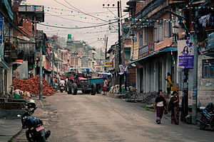
Besisahar

Besisahar
Besisahar
Besi Sahar.JPG
Basisdaten
Land: Flag of Nepal.svg Nepal
Zone: Gandaki
Distrikt: Lamjung
Geografische Lage: 28° 6′ N, 84° 26′ O28.184.433333333333Koordinaten: 28° 6′ N, 84° 26′ O
Zeitzone: UTC +5:45
Höhenlage: 780 m ü. NN
Einwohnerzahl:
Lage in Nepal
Besisahar (Nepal)
Besisahar
Besisahar

Besisahar (manchmal auch Besi Sahar) ist der Hauptort des nepalesischen Distrikts Lamjung. In südlicher Richtung ist Besisahar über Dumre an den Prithvi Highway, die Hauptstraße zwischen Kathmandu und Pokhara, angebunden. Da die befestigte Straße in Besisahar endet, ist es ein wichtiger Ausgangspunkt für Treks auf dem Annapurna Circuit und der Manaslurunde.


Wikimedia Foundation.

Игры ⚽ Поможем написать реферат

Schlagen Sie auch in anderen Wörterbüchern nach:

  • Besisahar — Administration Pays   …   Wikipédia en Français

  • Besisahar — is the capital of Lamjung District in Gandaki Zone, Nepal. [ [http://www.lflp.gov.np/index.php?show=lamjung Lamjung District] ] ee also* Lamjung DistrictReferences …   Wikipedia

  • Lamjung (Distrikt) — लमजुङ जिल्ला Distrikt Lamjung Lage des Distriktes Lamjung (rot) in Nepal, die Verwaltungszone Gandaki ist dunkelgrau markiert. Basisdaten …   Deutsch Wikipedia

  • Бесисахар — Поселок Бесисахар Страна НепалНепал Зона …   Википедия

  • List of cities in Nepal — This is a list of cities in Nepal.Note: Not all of these localities listed are municipalities. municipalities, of which Nepal momentarily has 58, are marked with a (*). The listed names are the official names of the municipalities, nevertheless… …   Wikipedia

  • Manaslu — at sunrise Elevation 8,156 m (26,759 ft)  Ranked 8th …   Wikipedia

  • Gandaki Zone — The Gandaki zone lies in the western administrative region of Nepal. It is named as Sapta Ganadaki after the seven tributaries (Kali Gandak, Trishuli, Budhi Gandak, Marsyangdi, Madi, Seti Gandak, and Daraudi) that make up the Gandaki River.… …   Wikipedia

  • Districts of Nepal — Nepal This article is part of the series: Politics and government of Nepal Government …   Wikipedia

  • Lamjung District — Infobox Nepal district district = Lamjung District area = 1,692 population = 177,149 pop year = 2001 density = caption = region = established = languages = website = Lamjung District, a part of Gandaki Zone, is one of the seventy five districts… …   Wikipedia

  • Annapurna Circuit — Alle Annapurnagipfel gesehen von Pokhara aus: vl.n.r. Annapurna Süd, Annapurna I mit dem ebenfalls schneebedeckten Hiunchuli davor, Machapucharé (steile Spitze links der Bildmitte), Annapurna III (Bildmitte, im Hintergrund), Annapurna IV,… …   Deutsch Wikipedia

Share the article and excerpts

Direct link
Do a right-click on the link above
and select “Copy Link”