California State Highway 91
- California State Highway 91
-
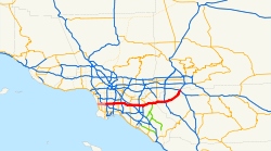
Die California State Route 91 ist eine State Route im US-Bundesstaat Kalifornien. Die von der Vermont Avenue in Torrance bis nach Riverside verlaufende State Route ist einer der bedeutendsten Ost-West-Verbindungen im Großraum Los Angeles und unterteilt sich in die drei Abschnitte Gardena-, Artesia- sowie Riverside Freeway. Die Länge der Straße beträgt 104,61 Kilometer.
Die CA-91 war ein Abschnitt des U.S. Highway 91, als er noch eine Fernverbindungsroute war. Diese Funktion wird heute vom Interstate 15 übernommen.
Siehe auch
Weblinks
Wikimedia Foundation.
Schlagen Sie auch in anderen Wörterbüchern nach:
California State Highway 1 — Karte … Deutsch Wikipedia
California State Route 89 — State Route 89 Sierra Highway … Wikipedia
California State Route 127 — State Route 127 Death Valley Road … Wikipedia
California State Route 88 — Infobox road state=CA type=SR route=88 section=388 maint=Caltrans length mi=122 length round=0 length ref= [ [http://www.dot.ca.gov/hq/structur/strmaint/brlog2.htm January 1, 2006 California Log of Bridges on State Highways] ] direction a=West… … Wikipedia
California State Route 52 — Infobox road state=CA type=SR route=52 section=352 maint=Caltrans length mi=15 length round=0 length ref=Fact|date=January 2008 established= direction a=West terminus a=jct|state=CA|I|5 in San Diego direction b=East terminus b=jct|state=CA|SR|125 … Wikipedia
California State Route 121 — Infobox road state=CA type=SR route=121 section=421 maint=Caltrans length mi=33.567 length round=2 length ref=California Department of Transportation, [http://www.dot.ca.gov/hq/traffops/trucks/truckmap/truck route list.xls State Truck Route List] … Wikipedia
California State Route 54 — Infobox road state=CA type=SR route=54 section=354 maint=Caltrans length mi=15 length round=0 length ref= [ [http://www.dot.ca.gov/hq/structur/strmaint/brlog2.htm January 1, 2006 California Log of Bridges on State Highways] ]… … Wikipedia
California State Route 84 — Infobox road state=CA type=SR route=84 section=384 maint=Caltrans length mi=96 length round=0 length ref= [ [http://www.dot.ca.gov/hq/structur/strmaint/brlog2.htm January 1, 2006 California Log of Bridges on State Highways] ] direction a=South… … Wikipedia
California State Route 55 — Karte … Deutsch Wikipedia
California State Route 170 — Infobox road state=CA type=SR route=170 alternate name=Hollywood Freeway section=470 maint=Caltrans length mi=7.637 length round=3 length ref= length notes=(plus about 4 mi (6 km) on US 101) established=1964 direction a=South terminus a=jct|state … Wikipedia