- Buffalo Bill State Park
-
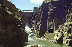
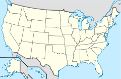
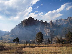
Buffalo Bill State Park Der Staudamm im Buffalo Bill State Park Lage: Wyoming, Vereinigte Staaten Nächste Stadt: Cody (WY) Gründung: 1957 Kleines Lauffeuer im Buffalo Bill State Park 44.50111111-109.183889Koordinaten: 44° 30′ 4″ N, 109° 11′ 2″ WDer Buffalo Bill State Park ist ein State Park in der Nähe der Ortschaft Cody im Park County, östlich des Yellowstone-Nationalparks im US-Bundesstaat Wyoming. Zentrum des Parks ist das Buffalo Bill Reservoir, ein Wasserreservoir am Shoshone River. Benannt ist der Park nach William Frederick Cody, besser bekannt als Buffalo Bill.
Inhaltsverzeichnis
Geschichte
William Cody hielt sich seit den 1870er Jahren in der Region um die heutige Ortschaft Cody auf, die er 1896 gründete. 1905 begann die Arbeit am Staudamm auf einem Grundstück, das die US-Bundesregierung teilweise von William Cody erworben hatte. Die Arbeiten am Damm dauerten bis 1910. Der Damm war damals mit rund 100 Metern (32 feet) der weltweit Höchste.[1] Das gestaute Wasser wurde zur Bewässerung und seit 1922 zur Stromerzeugung[2] genutzt.
1957 wurde die touristische Infrastruktur entlang des Ufers des Stausees ausgebaut und der State Park gegründet. Ab 1985 wurde der Damm um 8 Meter (25 feet) erhöht und damit auch das Wasserreservoir um 260.000 Acre-feet vergrößert.[3] Als Folge daraus musste die touristische Infrastruktur an der erweiterten Uferlinie neu angelegt werden, dies dauerte bis 1993.[1] Ebenfalls 1993 wurde ein privat betriebener Visitor Center eröffnet.[4]
Touristische Nutzung
Der Buffalo Bill State Park bietet vor allem Erholungsmöglichkeiten im und am Wasser: Fischen, Bootsfahren, Wandern und Campieren. Übernachtungsmöglichkeiten stehen in zwei Campingplätzen zur Verfügung. Der Park ist über den U.S. Highway 20 erreichbar.
Siehe auch
Einzelnachweise
- ↑ a b Wyoming State Parks, Historic Sites & Trails: Broschüre und Karte vom Park (engl.) (abgerufen am 28. Dezember 2010)
- ↑ Buffalo Bill Dam & Visitor Center: Shoshoni Power Plant (abgerufen am 28. Dezember 2010)
- ↑ Buffalo Bill Dam & Visitor Center: Modification Project (abgerufen am 28. Dezember 2010)
- ↑ Buffalo Bill Dam & Visitor Center (abgerufen am 28. Dezember 2010)
Weblinks
-
 Commons: Buffalo Bill State Park – Sammlung von Bildern, Videos und Audiodateien
 - Offizielle Website (englisch)
State Parks des US-Bundesstaates WyomingBear River | Boysen | Buffalo Bill | Curt Gowdy | Edness K. Wilkins | Glendo | Guernsey | Hawk Springs | Hot Springs | Keyhole | Seminoe | Sinks Canyon |
Wikimedia Foundation.
Schlagen Sie auch in anderen Wörterbüchern nach:
Buffalo Bill State Park — is a state park located in Park County, Wyoming, United States. The park surrounds a reservoir formed by the Buffalo Bill Dam on the Shoshone River. The park, reservoir and dam were named after William Buffalo Bill Cody who founded the nearby… … Wikipedia
Buffalo Bill — Buffalo Bill … Deutsch Wikipedia
Buffalo Bill Dam — vom Shoshone Canyon aus gesehen … Deutsch Wikipedia
Buffalo Bill Reservoir — Buffalo Bill Dam Buffalo Bill Dam vom Shoshone Canyon aus gesehen … Deutsch Wikipedia
Buffalo Bill Dam — Infobox Dam dam name=Buffalo Bill Dam caption=Buffalo Bill Dam from within Shoshone Canyon official name=Buffalo Bill Dam crosses= Shoshone River reservoir= Buffalo Bill Reservoir locale=Wyoming, USA maint= U.S. Bureau of Reclamation length= 200… … Wikipedia
Buffalo Bill Ranch — State Historical Park, also known as Scout s Rest Ranch, is a living history park located west of North Platte, Nebraska.The property includes a home owned by Buffalo Bill, as well as many other historical exhibits. The park can be found along… … Wikipedia
Buffalo Bill Cody Scenic Byway — is in the U.S. state of Wyoming and spans most of the distance from Cody, Wyoming to Yellowstone National Park. The 27.5 miles (44.3 km) scenic highway follows the north fork of the Shoshone River through the Wapiti Valley to Sylvan Pass and the… … Wikipedia
Buffalo Bill — Infobox Person name = William Frederick Cody image size = 200px caption = birth name = birth date = February 26, 1846 birth place = near Le Claire, Iowa, United States death date = dda|1917|1|10|1846|2|26 death place = Denver, Colorado, United… … Wikipedia
Park County (Wyoming) — Park County Courthouse in Cody Verwaltung US Bundesstaat: Wyoming … Deutsch Wikipedia
Monson Lake State Park — Coordinates: 45°19′14″N 95°16′13″W / 45.32056°N 95.27028°W / 45.32056; 95.27028 … Wikipedia


