Aberdares

Aberdares
Aberdare Nationalpark
IUCN-Kategorie II
Markierung
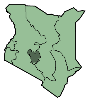
Lage des Parks in Kenia
Lage: Kenia
Geographische Lage: 0° 23′ S, 36° 42′ O-0.3836.6991666666677Koordinaten: 0° 22′ 48″ S, 36° 41′ 57″ O
Fläche: 766 km²
Einrichtungsdatum: 1950
Verwaltungsbehörde: Kenya Wildlife Service

Der Aberdare-Nationalpark liegt im Hochland der Central Province, etwa 100 km nördlich von Nairobi, Kenia.

Eingang des Aberdare-Nationalparks

Der Nationalpark hat eine Fläche von 766 km². Er besteht aus der Aberdare Range, einer Bergkette vulkanischen Ursprungs, die sich von Norden nach Süden erstreckt, und deren östlichen, dicht bewaldeten Vorgebirgen.

Zwischen den beiden größten Erhebungen, Ol Donyo Lesatima (3.999m) und Kinangop (3.906m), verläuft auf einer Höhe von über 3.000m ein Sattel alpiner Heidelandschaft. Schluchten mit Bächen und Wasserfällen durchtrennen bewaldete Hänge im Osten und Westen. Es ist ein wichtiges Wassereinzugsgebiet für den Tana- und Athi-River.

Das Wetter ist zum größten Teil des Jahres von Nebel und Regen geprägt. Häufig treten schwere Regenfälle, mit Niederschlagsmengen zwischen 1.000mm/Jahr an den nordwestlichen Hängen sowie 3.000mm/Jahr im Südosten, auf.[1]

Seinen offiziellen Namen erhielt der Nationalpark nach dem Entdecker der Region, Lord Aberdare, einem ehemaligen Präsidenten der Royal Geographical Society.

Die dunklen, feuchten Wälder des Gebiets dienten 19471956 als Unterschlupf für die Mau-Mau-Guerillabewegung.

Einzelnachweise

  1. Kenya Wildlife Service: Informationen zum Aberdare Nationalpark (englisch)

Weblinks


Wikimedia Foundation.

Игры ⚽ Нужен реферат?

Schlagen Sie auch in anderen Wörterbüchern nach:

  • Dendrosenecio — kilimanjari Scientific classification Kingdom: Plantae …   Wikipedia

  • Aberdare Range — The Aberdare Range (formerly, the Sattima Range, Kikuyu: Nyandarua ) is a 160 km long mountain range of upland north of Kenya s capital of Nairobi with an average elevation is 11,000 feet (3,350 metres). It is located in west central Kenya,… …   Wikipedia

  • Tragelaphus eurycerus — Para otros usos de este término, véase bongo (desambiguación).   Bongo …   Wikipedia Español

  • Nyeri — Nyeri …   Wikipedia

  • Aberdare National Park — Infobox protected area name = Aberdare National Park iucn category = II caption = Location of Aberdare National Park base width = 300px locator x = 110 locator y = 185 location = Kenya, Central Province nearest city = Nyeri lat degrees = 0 lat… …   Wikipedia

  • Melanism — The black panther is the prototypical example of melanism. Melanism is an undue development of dark colored pigment in the skin or its appendages, and the opposite of albinism. It is also the medical term for black jaundice.[1] The word is… …   Wikipedia

  • Happy Valley set — city locator base = Kenya relief map towns.jpg text x = 92 text y = 187 text=Nyeri base width = 300px base caption = Nyeri, Kenya (click to enlarge map) float = Locator Dot.gif float width = 10px float caption = Nyeri, Kenya x = 123 y = 188… …   Wikipedia

  • Rhino Ark — is a charity based in Kenya and the UK with a mission to raise funds and material support to build an electrified fence encircling both the Aberdares National Park and the demarcated forestry areas which make up the Aberdares Conservation Area.… …   Wikipedia

  • Buschböcke — Buschbock Männlicher Buschbock im Krüger Nationalpark Systematik Ordnung: Paarhufer (Artiodactyla) …   Deutsch Wikipedia

  • Schirrantilope — Buschbock Männlicher Buschbock im Krüger Nationalpark Systematik Ordnung: Paarhufer (Artiodactyla) …   Deutsch Wikipedia

Share the article and excerpts

Direct link
Do a right-click on the link above
and select “Copy Link”