Cape Flattery

Cape Flattery
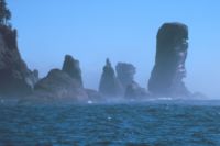
Der Fuca Pillar am Cape Flattery ist der nordwestlichste Punkt Washingtons, USA

Cape Flattery ist ein am Pazifischen Ozean gelegenes Kap. Es markiert den nordwestlichsten Punkt des geografisch zusammenhängenden Staatenverbandes der Vereinigten Staaten von Amerika (ohne Alaska und Hawaii).

Das Kap befindet sich auf der Halbinsel Olympic Peninsula im Landkreis Clallam County im Bundesstaat Washington. Hier endet die Juan-de-Fuca-Straße. Angrenzend liegen die Buchten Makah Bay und Neah Bay.

Der Leuchtturm Cape Flattery Lighthouse befindet sich auf der Insel Tatoosh Island. Die nächstgelegene Ortschaft ist Neah Bay.

Weblinks

 Commons: Cape Flattery – Sammlung von Bildern, Videos und Audiodateien
48.384722222222-124.72638888889

Wikimedia Foundation.

Игры ⚽ Поможем решить контрольную работу

Schlagen Sie auch in anderen Wörterbüchern nach:

  • Cape Flattery — may refer to : * Cape Flattery (Washington), * Cape Flattery (Queensland), between North and South Directon Island and Three Islands …   Wikipedia

  • Cape Flattery — (spr. Kehp Flattery), hohes Vorgebirg im äußersten NW. der Grafschaft Lewis, im Gebiete Washington (Vereinigte Staaten von Nordamerika), im SW. vom Stillen Ocean, im NO. von der Strait of Juan da Fuca bespült …   Pierer's Universal-Lexikon

  • Cape Flattery — Cette page d’homonymie répertorie les différents sujets et articles partageant un même nom. Cape Flattery peut faire référence à : Cape Flattery, dans l État de Washington aux États Unis, Cape Flattery, entre North et South Directon Island… …   Wikipédia en Français

  • Cape Flattery — Sp Flãterio kyšulỹs Ap Cape Flattery L JAV (Vašingtono v ja) …   Pasaulio vietovardžiai. Internetinė duomenų bazė

  • Cape Flattery (Washington) — Cape Flattery is the furthest northwest point of the contiguous United States. It is in Clallam County, Washington, where the Strait of Juan de Fuca empties into the Pacific Ocean. It is also part of the Makah Reservation, and is the northern… …   Wikipedia

  • Cape Flattery Light — Infobox Lighthouse caption = location = Neah Bay, Washington coordinates = coord|48.3917|N|124.7366|W|region:US type:landmark yearlit = 1857 automated = 1977 yeardeactivated = foundation = Surface construction = shape = Conical height = 65 ft… …   Wikipedia

  • Cape Flattery — noun a cape of northwestern Washington • Instance Hypernyms: ↑cape, ↑ness • Part Holonyms: ↑Washington, ↑Evergreen State, ↑WA …   Useful english dictionary

  • Flattery — (also called adulation or blandishment) is the act of giving excessive compliments, generally for the purpose of ingratiating oneself with the subject. Flattery often, but not always, connotes insincerity.Historically, flattery has been used as a …   Wikipedia

  • Cape Alava — Cape Alava, in Clallam County, Washington, U.S.A., is the westernmost point in the contiguous 48 states, with a longitude of nowrap|124° 44′ 11.8″ W (during low tide and walking out to the west side of Tskawahyah Island). The westernmost point is …   Wikipedia

  • Cape York Peninsula — This article is about the peninsula located in the Australian state of Queensland; it should not be confused with either Yorke Peninsula in South Australia, or Cape York, Greenland. Cape York Peninsula is a large peninsula located in Far North… …   Wikipedia

Share the article and excerpts

Direct link
Do a right-click on the link above
and select “Copy Link”