Flowerpot Island

Flowerpot Island

Vorlage:Infobox Insel/Wartung/Höhe fehlt

Flowerpot Island
Felsformationen am Ufer von Flowerpot Island
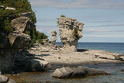
Gewässer Huronsee
Geographische Lage 45° 18′ 22″ N, 81° 36′ 6″ W45.306225-81.601780555556Koordinaten: 45° 18′ 22″ N, 81° 36′ 6″ W
Flowerpot Island (Ontario)
Flowerpot Island
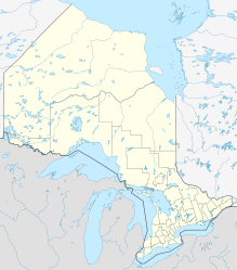
Länge 2,1 km
Breite 1,5 km
Fläche 2 km²
Einwohner (unbewohnt)

Flowerpot Island (dt. „Blumentopf-Insel“) ist eine unbewohnte Insel in der Georgsbucht des Huronsees. Sie gehört zur kanadischen Provinz Ontario und liegt zwischen der Bruce-Halbinsel im Süden und der Insel Manitoulin im Norden. Die Insel ist 2,1 km lang, 1,5 km breit und weist eine Fläche von etwa 2 km² auf. Sie ist Bestandteil des Fathom Five National Marine Parks und bekannt für ihre Blumentopf-ähnlichen Felsformationen am Ufer, denen die Insel ihren Namen verdankt.

Weblinks

 Commons: Flowerpot Island – Sammlung von Bildern, Videos und Audiodateien

Wikimedia Foundation.

Игры ⚽ Поможем сделать НИР

Schlagen Sie auch in anderen Wörterbüchern nach:

  • Flowerpot Island — is an island in Georgian Bay, and is a part of the Fathom Five National Marine Park of Ontario, Canada. The island spans 2.1 km from east to west, and 1.5 km from north to south, and has a total area of 2 km² (500 acres). It has 6 km of trails on …   Wikipedia

  • Flowerpot Island — Big Flowerpot (el gran Florero), una formación calcárea erosionada por las aguas, el hielo y el viento. Flowerpot Island es una isla canadiense ubicada en la Georgian Bay, una bahía de grandes proporciones en el Lago Hurón, en la provincia de… …   Wikipedia Español

  • Island Records discography — Given the longevity of the Island Records record label it is inevitable that a large amount of data has to be gathered, managed and presented not only correctly but also usably. To this end, the label s history (and this discography) can… …   Wikipedia

  • Cove Island Light — Cove Island Lighthouse, June 2008 Location Northeast shore of Cove Island at Gig Point, five miles north of the Bruce Peninsula. Coordinates …   Wikipedia

  • Île Flowerpot — 45° 18′ 22″ N 81° 38′ 06″ W / 45.306225, 81.635113 …   Wikipédia en Français

  • Cove Island lighthouse — Infobox Lighthouse caption = Cove Island Lighthouse, June 2008 location = Northeast shore of Cove Island at Gig Point, five miles north of the Bruce Peninsula. yearbuilt = Construction began in 1855 [ [http://coveisland.ca/3 history.html Cove… …   Wikipedia

  • Corporation Island — and the Flowerpots beyond, from Richmond Bridge Corporation Island is an island in the River Thames in England. It is on the Tideway near Twickenham between Richmond Bridge and Richmond Railway Bridge and is opposite the river frontage at… …   Wikipedia

  • Fathom Five National Marine Park — Flowerpot Island Der Fathom Five National Marine Park, der sich über eine Fläche von 130km² hinzieht, ist als erster Marine Nationalpark in Ontario (Kanada) auch der erste Nationalpark Kanadas, der historische Schiffswracks zur Schau stellt. Des… …   Deutsch Wikipedia

  • Bruce County, Ontario — Infobox Settlement name = official name =Bruce County other name = native name = nickname = settlement type =County total type = motto = imagesize = image caption = flag size = image seal size = image shield = shield size = image blank emblem =… …   Wikipedia

  • Stack (geomorfología) — Old Man of Hoy, Escocia …   Wikipedia Español

Share the article and excerpts

Direct link
Do a right-click on the link above
and select “Copy Link”