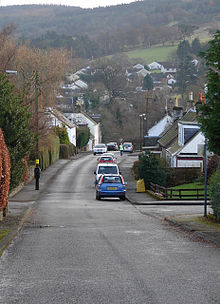
Gargunnock

Gargunnock
Gargunnock
Koordinaten 56° 7′ N, 4° 5′ W56.124722222222-4.0836111111111Koordinaten: 56° 7′ N, 4° 5′ W
Gargunnock (Schottland)
Gargunnock
Gargunnock
Bevölkerung 694 (Zensus 2001)
Verwaltung
Post town STIRLING
Postleitzahlen­abschnitt FK8
Vorwahl 01786
Landesteil Scotland
Unitary authority Stirling
Britisches Parlament Stirling
Schottisches Parlament Stirling
Gargunnock

Gargunnock ist eine Ortschaft in der schottischen Unitary Authority Stirling. Gargunnock ist etwa neun Kilometer westlich von Stirling und 28 km nordnordöstlich des Zentrums von Glasgow gelegen. Im Jahre 2001 wurden 694 Einwohner verzeichnet.[1]

Zwischen 1795 und 1923 wurde in Gargunnock Standort die überregional bedeutende Whiskybrennerei Glenfoyle betrieben, die aus der Aufspaltung der ehemaligen Kepp-Brennerei entstanden war. Die Easterkepp-Brennerei, die als zweiter Betrieb aus der Aufspaltung hervorging, wurde 1842 geschlossen.[2][3] Heute wohnen in Gargunnock viele Auspendler.[4]

Einzelnachweise

  1. Statistische Daten
  2. A. Barnard: The Whisky Distilleries of the United Kingdom, 1887, S. 295.
  3. Ulf Buxrud: Lost Scotch Malt Whisky Distilleries 1888–1945, 2000
  4. Eintrag im Gazetteer for Scotland

Wikimedia Foundation.

Игры ⚽ Поможем написать курсовую

Schlagen Sie auch in anderen Wörterbüchern nach:

  • Gargunnock — is a small village in the Stirling council area approximately seven miles west of Stirling, in Scotland. The 2001 census population was 944. It is situated on the south edge of the Carse of Stirling, at the feet of the Gargunnock Hills, part of… …   Wikipedia

  • Gargunnock —    GARGUNNOCK, a parish, in the county of Stirling, 6 miles (W.) from Stirling; containing 803 inhabitants, of whom 319 are in the village. This place, anciently called Gargownno, is supposed to have derived its name from the Celtic words Caer… …   A Topographical dictionary of Scotland

  • Clan Campbell — Crest badge …   Wikipedia

  • St. Ninians — is a long standing settlement which is now a district of the city of Stirling in central Scotland. It is located approximately one mile south of the city centre.It was originally known as Eccles (ie. church ), and may have been a Christian site… …   Wikipedia

  • Clan Campbell — crest badge du clan Campbell …   Wikipédia en Français

  • Glenfoyle — Land Schottland Region Highlands Geographische Lage …   Deutsch Wikipedia

  • Stirlingshire —    STIRLINGSHIRE, a county, in the eastern part of Scotland, bounded on the north by Perthshire and Clackmannanshire; on the east by the county of Linlithgow; on the south east by part of Lanarkshire; and on the south, and also on the west, by… …   A Topographical dictionary of Scotland

  • Dunblane — Coordinates: 56°11′02″N 3°58′03″W / 56.183827°N 3.967410°W / 56.183827; 3.967410 …   Wikipedia

  • Doune — Castle seen from the arch bridge over the River Teith. The town of Doune is situated to the left, out of the shot. Doune (Gaelic: An Dùn, the fort ) is a burgh in the district of Stirling, Scotland, on the River Teith. Doune s postal address… …   Wikipedia

  • Stirlingshire — For ships named Stirlingshire, see MV Stirlingshire. central   County (until circa 1890)   File:Stirling Country Scotland County town …   Wikipedia

Share the article and excerpts

Direct link
Do a right-click on the link above
and select “Copy Link”