Hambleton Hills

Hambleton Hills
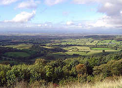
Hambleton Hills: Blick auf das Vale of Mowbray

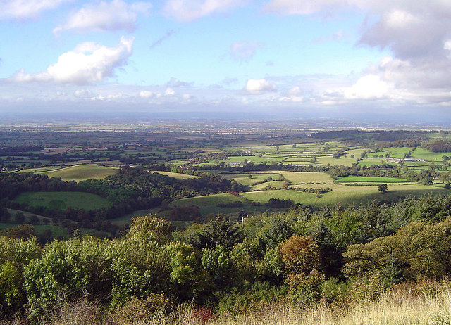
Die Hambleton Hills sind eine Hügelkette in Yorkshire in Nordostengland. Die Kalksteinformationen bilden die südwestliche Grenze der North York Moors zum Vale of York und dem Vale of Mowbray. Im Gegensatz zum aus Sandstein bestehenden Hauptteil der Moors-Hochebene zeichnen sich die Hambleton Hills durch zahlreiche Steilhänge und dramatische Kliffs aus. Gegenüber den Ebenen von Vale of York and Vale of Mowbray wirken die mehrere hundert Meter hohen Steinvertikalen uneinnehmbar, von Aussichtspunkten wie Sutton Bank kann man bis zu 50 Kilometer in die Ferne sehen.

Der National Trail Cleveland Way verläuft hier entland der Kliffränder. Die bekannteste davon ist Sutton Bank. Getrennt durch das Ryedale setzen sich die Hambleton Hills nach Norden in den Tabular Hills fort. In diese Richtung sind die Hänge wesentlich flacher.[1] Höchster Punkt der Hills ist Black Hambleton mit knapp 400 Metern Höhe.[2]

Anmerkungen

  1. Martin Collins, Paddy Dillon: The North York Moors: A Walking Guide, Cicerone Press Limited, 2008, ISBN 1852844485, S. 63
  2. Martin Collins, Paddy Dillon: The North York Moors: A Walking Guide, Cicerone Press Limited, 2008, ISBN 1852844485, S. 77
54.314641-1.209297

Wikimedia Foundation.

Игры ⚽ Поможем решить контрольную работу

Schlagen Sie auch in anderen Wörterbüchern nach:

  • Hambleton Hills — Sp Hámbltono kalvos Ap Hambleton Hills L Jungtinė Karalystė (Anglija) …   Pasaulio vietovardžiai. Internetinė duomenų bazė

  • Hambleton — Para otros usos de este término, véase Hambleton (desambiguación). Hambleton Distrito del Reino Unido …   Wikipedia Español

  • Hambleton — ▪ district, England, United Kingdom       district, administrative county of North Yorkshire, northern England, historic county of Yorkshire, England. It includes part of the Cleveland Hills, whose southern extension is known as the Hambleton… …   Universalium

  • Hambleton — Infobox UK district name = Hambleton District status = District region = Yorkshire and the Humber admincounty = North Yorkshire area = Ranked 10th 1,311.17 km² adminhq = Northallerton onscode = 36UC population = Ranked English district… …   Wikipedia

  • Hambleton — This uncommon name is of Anglo Saxon origin, and is a locational surname deriving from any one of the places called Hambleton in Lancashire, Rutland and Yorkshire. The place in Lancashire, near Garstang, is recorded as Hameltune in the Domesday… …   Surnames reference

  • Carlton, Hambleton — Carlton in Cleveland is a village and civil parish in the Hambleton district of North Yorkshire, England, on the edge of the North York Moors National Park. It is about 12 miles south of Middlesbrough. According to the 2001 census it had a… …   Wikipedia

  • North York Moors — Heide , Farn und Weidelandschaft der North York Moors Die North York Moors sind eine Hochebene in North Yorkshire im Nordosten Englands. Das 1436 km² große, südöstlich von Middlesbrough direkt an der Nordsee gelegene Gebiet erhebt sich etwa… …   Deutsch Wikipedia

  • Cowesby — Looking cross the fields to Cowesby with the Hambleton Hills beyond Cowesby is a village and civil parish in the Hambleton district of North Yorkshire, England. it is on the border of the North Yorkshire Moors and near the A19, about 4 miles… …   Wikipedia

  • North York Moors — Protected Area The North York Moors from space Country …   Wikipedia

  • River Derwent, Yorkshire — Geobox River name = Derwent native name = other name = Darwent archaically other name1 = map size = map caption = Map of the Catchment Area of the River Derwent country = England country1 = region = Yorkshire region1 = city = city1 = length = 115 …   Wikipedia

Share the article and excerpts

Direct link
Do a right-click on the link above
and select “Copy Link”