Hanbury Street

Hanbury Street
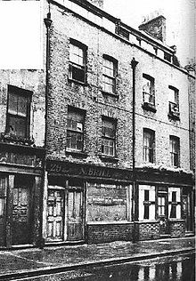
Ein Teil der Hanbury Street wie sie zur Zeit Jack the Rippers aussah. In der Mitte des Bildes ist 29 Hansbury Street zu sehen, in dessen Hinterhof Annie Chapman gefunden wurde. Heute steht an derselben Stelle ein Parkhaus.

Hanbury Street ist eine Straße im Londoner Stadtteil Spitalfields, die sich östlich von Commercial Street erstreckt. Ursprünglich hieß die aus dem 17. Jahrhundert stammende Straße Browne’s Lane [1].

Die Straße erlangte am 8. September 1888 traurige Berühmtheit, als um 6 Uhr morgens die Leiche von Annie Chapman im Hinterhof des Hauses Nummer 29 gefunden wurde. Sie gilt als zweites Opfer der vermuteten Mordserie durch Jack the Ripper. Heute dient Hanbury Street hauptsächlich als Wohn- und Geschäftsstraße. Das Haus Nummer 29 ist nicht mehr erhalten, an dessen Stelle steht heute ein Parkhaus.

Literatur

  • Donald Rumbelow. The Complete Jack the Ripper (True Crime). Fully revised and updated edition. Penguin Books Ltd. London 2004, ISBN 0-14-017395-1.
  • Steward P. Evans, Keith Skinner: Jack the Ripper and the Whitechapel Murders. Public Records Office, Richmond 2002, ISBN 1-903365-39-2.

Einzelnachweise

  1. Fiona Rule: The Worst Street in London. Seite 22. Ian Allen Publishing. Hersham 2008
51.513969-0.077926999999988

Wikimedia Foundation.

Игры ⚽ Нужно решить контрольную?

Schlagen Sie auch in anderen Wörterbüchern nach:

  • Hanbury Street — is a street in Spitalfields, London Borough of Tower Hamlets, in the East End of London. In the early morning of 9 September 1888, the mutilated body of prostitute Annie Chapman was found in the garden of #29 Hanbury Street. Like other… …   Wikipedia

  • Sherlock Holmes contre Jack l'Éventreur (jeu vidéo) — Pour les articles homonymes, voir Sherlock Holmes contre Jack l Éventreur. Sherlock Holmes Contre Jack l Éventreur …   Wikipédia en Français

  • Sherlock Holmes contre Jack l'Eventreur — Sherlock Holmes contre Jack l Éventreur (jeu vidéo) Sherlock Holmes Contre Jack l Éventreur Éditeur Focus Home Interactive …   Wikipédia en Français

  • Mayfield, New South Wales — Mayfield Newcastle, New South Wales A mosaic map of Mayfield Population …   Wikipedia

  • Spitalfields — infobox UK place country = England map type = Greater London region= London population= official name= Spitalfields latitude= 51.5166 longitude= 0.0750 os grid reference= TQ335815 post town= LONDON postcode area=E postcode district=E1 london… …   Wikipedia

  • Asesinatos de Whitechapel — El Nemesis de negligencia , una imagen de la miseria social, se manifiesta como Jack el Destripador , Dibujos de Whitechapel de un sacador de dibujos animados de 1888 por Sir John Tenniel Los asesinatos de Whi …   Wikipedia Español

  • Annie Chapman — (born Ann Eliza Smith, c. 1841 8 September 1888) was a victim of the notorious unidentified serial killer Jack the Ripper, who killed and mutilated several women in the Whitechapel area of London during the late summer and autumn of 1888.Life and …   Wikipedia

  • Morada — For Morada in California, see Morada, California. Morada Home Limited Type Private Industry Household Goods Founded London 1876 Headquarters Altham, Lancashire, England …   Wikipedia

  • Jack the Ripper — Infobox Serial Killer name=Jack the Ripper caption= A Suspicious Character, from The Illustrated London News for 13 October 1888 carrying the overall caption, With the Vigilance Committee in the East End . birthname= Unknown alias=Saucy… …   Wikipedia

  • Jack l'Éventreur — Pour les articles homonymes, voir Jack l Éventreur (homonymie). Évocation de Jack l Éventreur en une du journal satirique Puck Jack l Éventreur (en anglais …   Wikipédia en Français

Share the article and excerpts

Direct link
Do a right-click on the link above
and select “Copy Link”