Ilhéu das Cabras

Ilhéu das Cabras

Vorlage:Infobox Insel/Wartung/Bild fehltVorlage:Infobox Insel/Wartung/Fläche fehltVorlage:Infobox Insel/Wartung/Höhe fehlt

Ilhéu das Cabras
Gewässer
Geographische Lage 0° 24′ 30″ N, 6° 42′ 55″ O0.408333333333336.7152777777778Koordinaten: 0° 24′ 30″ N, 6° 42′ 55″ O
Ilhéu das Cabras (São Tomé und Príncipe)
Ilhéu das Cabras

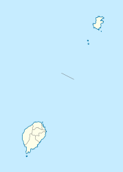
Ilhéu das Cabras ist eine kleine, zum westafrikanischen Staat São Tomé und Príncipe gehörende Insel im Golf von Guinea. Sie befindet sich zwei Kilometer vor der Nordostküste der Hauptinsel São Tomé, drei Kilometer nördlich des Flughafens São Tomé. Sie ist nicht dauerhaft bewohnt und gehört zum Distrikt Lobata.

Die Insel ist vulkanischen Ursprungs (Schichtvulkan).

Weblinks


Wikimedia Foundation.

Игры ⚽ Поможем написать курсовую

Schlagen Sie auch in anderen Wörterbüchern nach:

  • Ilhéu das Cabras — is an island in the Gulf of Guinea and is one of the smaller islands of São Tomé and Príncipe. The islet is located just north of the coast of the island of São Tomé north of the city of and east of the island s northernmost point and north of… …   Wikipedia

  • Ilhéu das Cabras — Localización. Ilhéu das Cabras es un islote que pertenece al país de Santo Tomé y Príncipe, en el Golfo de Guinea. El islote se encuenta al norte de la costa de la isla de Santo Tomé, a 0º N 6º O. No hay población permanente. Coordenadas …   Wikipedia Español

  • Cabras (Begriffsklärung) — Cabras kann sich auf folgende Orte beziehen: auf einen Ort auf Sardinien Cabras auf eine Inselkette bei Ilhabela, Brasilien, s. Ilha das Cabras auf eine kleine Insel vor São Tomé im Golf von Guinea, s. Ilhéu das Cabras eine längliche, zu Apra… …   Deutsch Wikipedia

  • Cabras — There are geographical features that begin with Cabras:*Cabras, Italy *Ilha das Cabras an island chain in the municipality of Ilhabela, São Paulo, Brazil *Ilhéu das Cabras an island chain located a few kilometres north of São Tomé Island in São… …   Wikipedia

  • Miradouro das Veredas — is a monument in the Azores. It is located in Angra do Heroísmo, on the island of Terceira. v · Angra do H …   Wikipedia

  • Miradouro do Pico das Cruzinhas — is a monument in the Azores. It is located in Angra do Heroísmo, on the island of Terceira. v · …   Wikipedia

  • List of São Tomé and Príncipe-related topics — This is a partial list of topics related to São Tomé and Príncipe. Geography * Extreme points of São Tomé and Príncipe * List of volcanoes in São Tomé and Príncipe Landforms Islands * Ilheu Bom Bom * Ilhéu das Cabras * Ilhéu Caroço * Ilhéu das… …   Wikipedia

  • Centro Histórico de Angra do Heroísmo — Central Zone of the Town of Angra do Heroismo in the Azores * UNESCO World Heritage Site The building along with the view …   Wikipedia

  • Geografía de Santo Tomé y Príncipe — Santo Tomé y Príncipe se encuentra situado en el Atlántico, al sur de la isla de Fernando Poo, (Guinea Ecuatorial) en el Golfo de Guinea. Dista 300 km al noroeste de la costa de Gabón, y es el país africano de menor superficie. El país está… …   Wikipedia Español

  • Liste der Inseln von São Tomé und Príncipe — Karte mit den wichtigsten Inseln von São Tomé und Príncipe Die Liste der Inseln von São Tomé und Príncipe enthält die Inseln, aus denen der Staat São Tomé und Príncipe im Atlantik vor der Küste Zentralafrikas besteht. Ilhéu Bom Bom Ilhéu das… …   Deutsch Wikipedia

Share the article and excerpts

Direct link
Do a right-click on the link above
and select “Copy Link”