Kaminak Lake

Kaminak Lake
Kaminak Lake

Photo-request.svg

Bild gesucht 

BW

Geographische Lage Nunavut (Kanada)
Zuflüsse Ferguson River
Abfluss Ferguson River
Daten
Koordinaten 62° 10′ 0″ N, 94° 59′ 59″ W62.166666666667-94.99972222222253Koordinaten: 62° 10′ 0″ N, 94° 59′ 59″ W
Kaminak Lake (Kanada)
Kaminak Lake
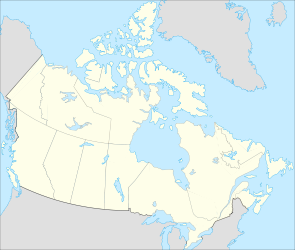
Höhe über Meeresspiegel 53 m
Fläche 554 km²[1]
Länge 60 kmf6

Kaminak Lake ist ein See im kanadischen Territorium Nunavut, 80 km westlich der Hudson Bay. Südlich des Sees liegt der Maguse Lake. Die Wasserfläche beträgt 554 km². Mit Inseln beträgt die Gesamtfläche 600 km².[1] Der See wird vom Ferguson River in östlicher Richtung durchflossen und zum benachbarten Quartzite Lake und zur Hudson Bay entwässert.

Einzelnachweise

  1. a b Natural Resources Canada - The Atlas of Canada - Nunavut

Wikimedia Foundation.

Игры ⚽ Поможем написать реферат

Schlagen Sie auch in anderen Wörterbüchern nach:

  • Kaminak Lake — Infobox lake lake name = Kaminak Lake image lake = caption lake = image bathymetry = caption bathymetry = location = Northern Canada coords = coord|62|13|N|95|00|W|region:CA type:waterbody|display=inline,title type = inflow = Ferguson River… …   Wikipedia

  • Kaminak Lake — Sp Kãminako ẽžeras Ap Kaminak Lake L Kanadoje (Nunavutas) …   Pasaulio vietovardžiai. Internetinė duomenų bazė

  • Qamanirjuaq Lake — Infobox lake lake name = Qamanirjuaq Lake image lake = caption lake = image bathymetry = caption bathymetry = location = Kivalliq Region, Nunavut coords = coord|63|00|00|N|95|45|00|W|region:CA type:waterbody|display=inline,title type = inflow… …   Wikipedia

  • Qamanirjuaq Lake — (Kaminuriak Lake) Bild gesucht  BW Geographische Lage Nunavut (Kanada) Zuflüsse …   Deutsch Wikipedia

  • Yathkyed Lake — Infobox lake lake name = Yathkyed Lake image lake = caption lake = image bathymetry = caption bathymetry = location = Northern Canada coords = coord|62|40|N|98|00|W|region:CA type:waterbody|display=inline,title type = inflow = Kazan River outflow …   Wikipedia

  • Nettilling Lake — is in the southern part of the island, being the upper of the two visible lakes. The lower lake is Amadjuak Lake. Location Baffin Island, Nunavut Territory …   Wikipedia

  • Dubawnt Lake — Location Kivalliq Region, Nunavut Coordinates 63°4′0″N …   Wikipedia

  • Henik Lake — North Henik Lake Location Kivalliq Region, Nunavut Coordinates 61°43′59″N …   Wikipedia

  • Contwoyto Lake — Location Kitikmeot Region, Nunavut Coordinates 65°40′N …   Wikipedia

  • Nueltin Lake — Location Manitoba/Nunavut Coordinates 60°09′03″N 099°45′ …   Wikipedia

Share the article and excerpts

Direct link
Do a right-click on the link above
and select “Copy Link”