Karamea Bight

Karamea Bight
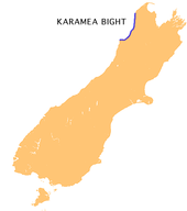
Die Karamea Bight auf der Südinsel

Die Karamea Bight ist eine weitläufige Bucht in der Tasmansee.

Sie erstreckt sich auf einer Länge von 100 Kilometern entlang der Westküste der Neuseeländischen Südinsel zwischen Cape Foulwind und der Mündung des Heaphy Rivers, hauptsächlich im Distrikt Buller in der Region West Coast.

Siehe auch

-41.356692171.909826

Wikimedia Foundation.

Игры ⚽ Поможем написать курсовую

Schlagen Sie auch in anderen Wörterbüchern nach:

  • Karamea Bight — The Karamea Bight is the name given to a large bay in the Tasman Sea formed by a curved stretch of the West Coast of New Zealand s South Island. It stretches for 100 kilometres north from Cape Foulwind to just north of the mouth of the Heaphy… …   Wikipedia

  • Karamea — Karamea …   Deutsch Wikipedia

  • Karamea — Infobox Settlement name = Karamea population total = 423 population as of = 2006 subdivision type = Country subdivision name = New Zealand subdivision type1= Region subdivision name1= West Coast subdivision type2= District subdivision name2=… …   Wikipedia

  • Orowaiti River — Mouth Karamea Bight Basin countries New Zealand Length 15 kilometres (9.3 mi) The Orowaiti River is a river of the West Coast Region of New Zealand s South Island. The smaller of the two rivers which run through the town of …   Wikipedia

  • Little Wanganui River — Little Wanganui RiverVorlage:Infobox Fluss/GKZ fehlt Lage Neuseeland Flusssystem Little Wanganui River Quelle Am Little Wanganui Saddle zwischen den Gebirgszügen Scarlett Range und Allen Range …   Deutsch Wikipedia

  • Waimangaroa River — The Waimangaroa River is located on the West Coast of New Zealand.The river passes through tussock, scrub and forested areas before draining into the Karamea Bight in the Tasman Sea. It passes through the town of Waimangaroa and is crossed by the …   Wikipedia

  • Ngakawau River — Mouth Karamea Bight Basin countries New Zealand Length 19 kilometres (12 mi) The Ngakawau River is a river of the West Coast Region of New Zealand s South Island. It flows generally northwest, reaching the Tasman Sea at …   Wikipedia

Share the article and excerpts

Direct link
Do a right-click on the link above
and select “Copy Link”