Keechelus Lake

Keechelus Lake
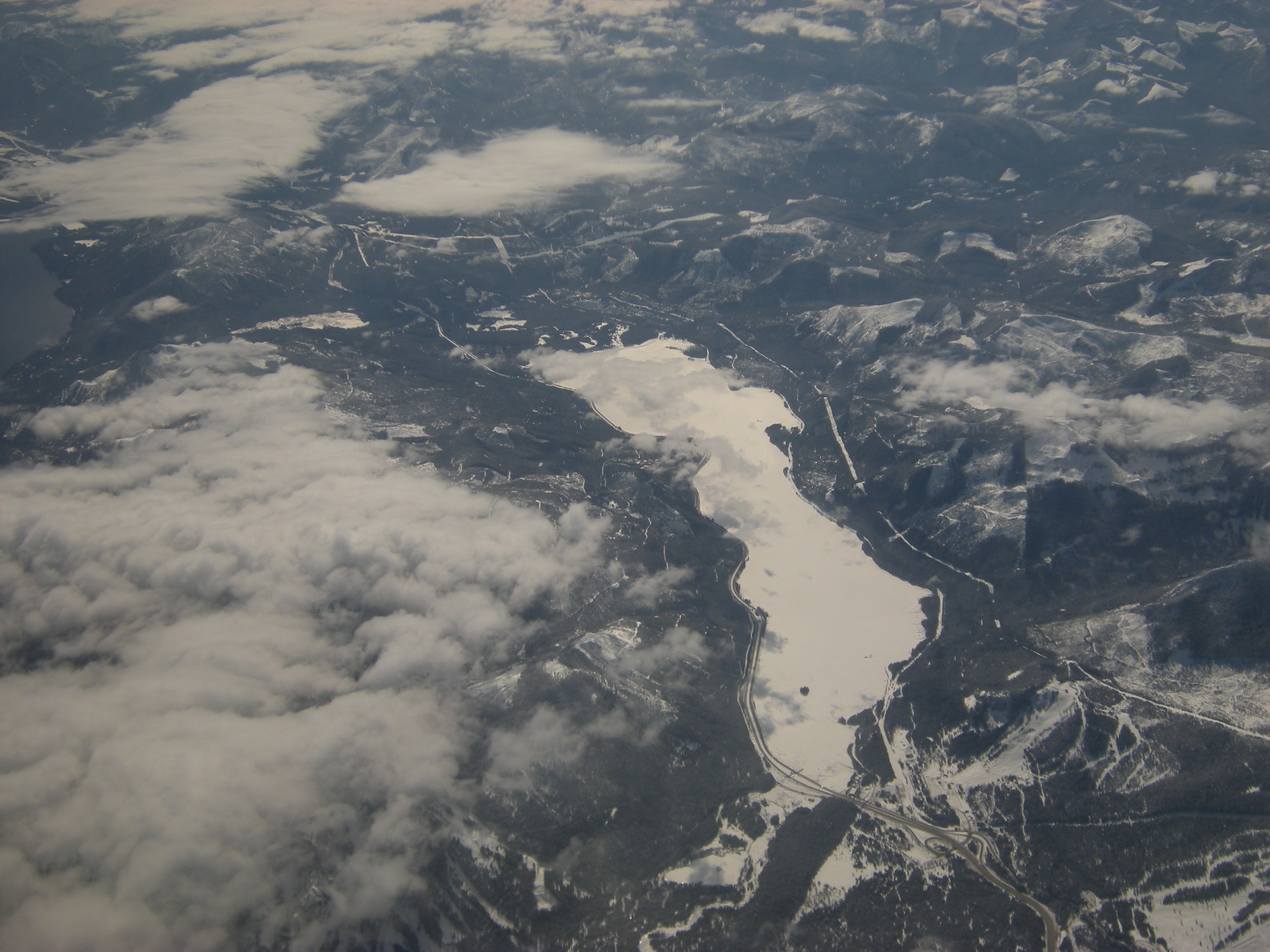
Keechelus Lake
Luftbild
Luftbild
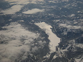
Lage: Washington, Vereinigte Staaten
Abflüsse: Yakima River
Keechelus Lake (Washington)
Keechelus Lake
Koordinaten 47° 19′ 20,4″ N, 121° 20′ 21,3″ W47.3223352-121.3392603Koordinaten: 47° 19′ 20,4″ N, 121° 20′ 21,3″ W
Daten zum Bauwerk
Sperrentyp: Erdstaudamm
Bauzeit: 1916
Höhe des Absperrbauwerks: 39 m
Bauwerksvolumen: 523.000 m³
Kronenlänge: 584 m
Daten zum Stausee
Wasseroberfläche bei Vollstau: 12,7 km²
Stauseelänge: 9 km
Speicherraum: 194 Mio. m³dep1

Der Keechelus Lake ist ein See im Kittitas County im US-Bundesstaat Washington. Der natürliche See liegt 16 km nordwestlich von Easton und wird durch den Keechelus Dam auf eine Größe von 12,7 km² aufgestaut. Der Abfluss des Sees gilt als Quelle des Yakima River.

Der Staudamm ist ein Erddamm und wurde vom Bureau of Reclamation als Teil des Yakima Project zur künstlichen Bewässerung erbaut. Der 1916 fertiggestellte Damm ist 39 m hoch und 584 m lang.

Der Name Keechelus stammt aus einer Indianersprache und bedeutet „fischarm“ im Gegensatz zum Kachess Lake, der „fischreich“ genannt wird[1]. Der See befindet sich im Wenatchee National Forest. Der See ist ein beliebtes Ziel für Wassersportler und Angler[2].

Weblinks

Einzelnachweise

  1. Phillips, James W. (1971). Washington State Place Names. University of Washington Press. ISBN 0-295-95158-3.
  2. www.recreation.gov: Keechelus Lake. Abgerufen am 17. Mai 2011.

Wikimedia Foundation.

Игры ⚽ Поможем решить контрольную работу

Schlagen Sie auch in anderen Wörterbüchern nach:

  • Keechelus Lake — Infobox lake lake name = Keechelus Lake image lake = Keechelus stump.jpg caption lake = image bathymetry = caption bathymetry = location = Kittitas County, Washington coords = Coord|47.3477| 121.3691|type:waterbody region:US… …   Wikipedia

  • Kachess Lake — Infobox lake lake name = Kachess Lake image lake = Kachess Lake (192351699).jpg caption lake = image bathymetry = caption bathymetry = location = Kittitas County, Washington coords = Coord|47.3191| 121.2397|type:waterbody region:US… …   Wikipedia

  • Cle Elum Lake — Location Kittitas County, Washington Coordinates …   Wikipedia

  • Kachess Lake — Kachess Lake …   Deutsch Wikipedia

  • Yakima River — Einzugsbereich des Yakima River Daten …   Deutsch Wikipedia

  • Yakima River — Geobox River name = Yakima River native name = other name = other name1 = image size = 300 image caption = State Route 10 winds past the Yakima River (©2004 Mountains to Sound Greenway Trust) country = United States country1 = state = Washington… …   Wikipedia

  • List of tributaries of the Columbia River — Tributaries and sub tributaries are hierarchically listed in order from the mouth of the Columbia River upstream. Major dams and reservoir lakes are also noted.Minor tributaries* Skipanon River (Oregon) * Lewis and Clark River (Oregon) * Youngs… …   Wikipedia

  • David Denny — This article is about the American pioneer. For the guitarist, see David Denny (musician). David Denny circa 1875 David Thomas Denny (March 17, 1832[1] November 25, 1903[2] …   Wikipedia

  • List of names in English with counterintuitive pronunciations — This is a set of lists of English personal and place names whose pronunciations are counterintuitive to their spelling, either because the pronunciation does not correspond to the spelling, or because a better known namesake has a markedly… …   Wikipedia

  • Mount Catherine (Washington) — Mount Catherine Elevation 5,052 ft (1,540 m) NGVD 29[1] Prominence …   Wikipedia

Share the article and excerpts

Direct link
Do a right-click on the link above
and select “Copy Link”