Chalky Island

Chalky Island

Vorlage:Infobox Insel/Wartung/Höhe fehlt

Chalky Island
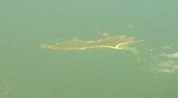
Luftaufnahme, Chalky Island
Gewässer Pazifischer Ozean
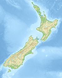
Geographische Lage 46° 3′ 0″ S, 166° 31′ 0″ O-46.05166.51666666667Koordinaten: 46° 3′ 0″ S, 166° 31′ 0″ O
Chalky Island (Neuseeland)
Chalky Island
Fläche 5,14 km²

Chalky Island ist eine 514 Hektar große Insel im Südwesten von Neuseeland und Teil des Fiordland National Park. Sie liegt am Eingang zum Chalky Inlet an der Südwestspitze der Südinsel, 10 km nordwestlich von Puysegur Point, 15 km südöstlich von West Cape und 140 km westlich von Invercargill.

Die Insel wurde zuerst 1773 von James Cook kartografiert und war im späten 18. Jahrhundert und frühen 19. Jahrhundert eine Basis für Robbenjäger.

Durch das Department of Conservation wurden alle Raubtiere auf der Insel ausgerottet, sie ist heute ein Vogelschutzgebiet und eines der zwei bedeutendsten von vier Schutzgebiete für den flugungähigen Papagei Kakapo.


Wikimedia Foundation.

Игры ⚽ Поможем написать реферат

Schlagen Sie auch in anderen Wörterbüchern nach:

  • Chalky Island — may refer to: Chalky Island (New Zealand) Chalky Island (Tasmania) Little Chalky Island, Tasmania This disambiguation page lists articles about distinct geographical locations with the same name. If an …   Wikipedia

  • Chalky Island, New Zealand — Chalky Island Location map of Chalky Island. Geography Location Southland Region Coordinates …   Wikipedia

  • Chalky Island (Tasmania) — Chalky Island aerial view from east Chalky Island is an island with an area of 41 ha, in south eastern Australia. It is part of Tasmania’s Big Green Island Group, lying in eastern Bass Strait west of Flinders in the Furneaux Group. It is composed …   Wikipedia

  • Chalky Island (New Zealand) — Chalky Island is a 514 ha island in the southwest of New Zealand, and is part of Fiordland National Park. It lies at the entrance to Chalky Inlet, at the southwestern tip of the South Island, ten kilometres northwest of Puysegur Point, 15… …   Wikipedia

  • Little Chalky Island — is a small, flat, granite island with an area of 5 ha, in south eastern Australia. It is part of Tasmania’s Big Green Island Group, lying in eastern Bass Strait west of Flinders in the Furneaux Group.Brothers, Nigel; Pemberton, David; Pryor,… …   Wikipedia

  • Chalky, Big Green and Badger Island Groups Important Bird Area — The islands of the IBA are home to up to 41,000 pairs of Little Penguins The Chalky, Big Green and Badger Island Groups Important Bird Area lies in eastern Bass Strait west of Flinders in the Furneaux Group of Tasmania, Australia. Its component… …   Wikipedia

  • Mount Chappell Island — was originally named Mount Chappelle by Matthew Flinders for his wife s maiden name.[1] It is a mainly dolerite island, with a distinctive central hill and with an area of 323 ha, in south eastern Australia. It is part of Tasmania’s Badger Island …   Wikipedia

  • Mile Island — is an island with an area of 4 ha, in south eastern Australia. It is part of Tasmania’s Big Green Island Group, lying in eastern Bass Strait west of Flinders in the Furneaux Group. It is a conservation area.[1] The island is also part of the… …   Wikipedia

  • Long Island Sound — is an estuary of the Atlantic Ocean and various rivers in the United States that lies between the coast of Connecticut to the north and Long Island, New York to the south. The mouth of the Connecticut River at Old Saybrook, Connecticut empties… …   Wikipedia

  • Kakapo — Conservation status Critically Endangered ( …   Wikipedia

Share the article and excerpts

Direct link
Do a right-click on the link above
and select “Copy Link”