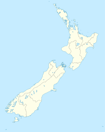
Leeston

Leeston
Leeston
Leeston (Neuseeland)
Leeston
Koordinaten 43° 46′ S, 172° 18′ O-43.766666666667172.3Koordinaten: 43° 46′ S, 172° 18′ O
Einwohner 1.299 (2006)
Region Canterbury
Distrikt Selwyn-Distrikt

Leeston ist ein Ort im Selwyn-Distrikt in der Region Canterbury auf der Südinsel von Neuseeland. Er liegt in den Canterbury Plains etwa 40 Kilometer südwestlich von Christchurch, unweit des Pazifischen Ozeans zwischen dem Lake Ellesmere und dem Rakaia River. Beim Zensus 2006 wurden 1.299 Einwohner gezählt.[1]

Woher die Stadt ihren Namen hat, ist nicht mit Gewissheit zu belegen. Möglicherweise wurde sie nach dem gleichnamigen Ort im englischen Cornwall benannt, in dem der vormalige Grundbesitzer F.J. Smith geboren wurde, der seinerzeit das Land zur Siedlungsgründung stiftete.

Wenn man von Norden nach Leeston hineinkommt, trifft man bald auf ein imposantes Kriegsdenkmal. Einige Straßennamen verweisen zudem auf bedeutende Schlachtfelder des Ersten Weltkriegs (zum Beispiel auf die türkische Hafenstadt Gallipoli, wo im Jahre 1915 unter Beteiligung von neuseeländischen Truppen eine der blutigsten Schlachten des Krieges geschlagen wurde).

Leeston war Hauptsitz des Selwyn-Distrikts, bevor dieser in die größere Ortschaft Rolleston verlegt wurde. Das Council unterhält aber immer noch ein Büro in der Stadt.[2]

Der neuseeländische Rugby Union-Spieler Daniel Carter, der auch schon für das Nationalteam All Blacks zum Einsatz gekommen ist, wurde in Leeston geboren.

Weblinks

Selwyn District, Leeston

Quellen

  1. Statistics New Zealand, Leeston
  2. Selwyn District Council

Wikimedia Foundation.

Игры ⚽ Поможем решить контрольную работу

Schlagen Sie auch in anderen Wörterbüchern nach:

  • Leeston — Location map New Zealand label=Leeston lat dir=S | lat deg=43 | lat min=46 lon dir=E | lon deg=172 | lon min=18 position=right width= 150 float=right caption=Leeston is a small town with a population of 1,299 [cite web… …   Wikipedia

  • Leeston — Original name in latin Leeston Name in other language Leeston Town District State code NZ Continent/City Pacific/Auckland longitude 43.76667 latitude 172.3 altitude 18 Population 1272 Date 2011 08 01 …   Cities with a population over 1000 database

  • Michael Leeston-Smith — born in 1916, (aged 94 or 95) is a British director. Leeston Smith took a job at Ealing Studios in 1932, aged 16. He worked there as a photographer and assistant sound engineer. In 1938 he was sent by the BBC to their studios in Daventry.[1]… …   Wikipedia

  • Doyleston — …   Wikipedia

  • Darby Loudon — Full name Darby Briton Loudon[1] Date of birth 12 March 1897(1897 03 12)[1] Place of birth Leeston …   Wikipedia

  • Southbridge, New Zealand — Southbridge is a small town with a population of 720 [http://www2.stats.govt.nz/domino/external/web/CommProfiles.nsf/FindInfobyArea/597400 au ] and approximately 260 houses, on the Canterbury Plains in the South Island of New Zealand. It is… …   Wikipedia

  • Ellesmere College (New Zealand) — Infobox NZ school name =Ellesmere College badge = motto = Strive For Perfection type = State, Co educational, Secondary established = 1981 address =Tramway Road, Leeston coordinates = principal =Ken Dawson roll =569 decile =8 MOE =349 homepage =… …   Wikipedia

  • Southbridge Branch, New Zealand — The Southbridge Branch was a branch line railway that formed part of New Zealand s national rail network. It was located in the Canterbury region of the South Island and operated from 1875 until 1967. A small portion of the line remains open as… …   Wikipedia

  • Dunsandel — Coordinates: 43°40′S 172°11′E / 43.667°S 172.183°E / 43.667; 172.183 …   Wikipedia

  • Central Plains Water — is the name given to the Central Plains Water Enhancement Scheme, the Central Plains Water Trust and a company, Central Plains Water Limited, involved with the promotion of a water diversion, damming and water reticulation and irrigation scheme… …   Wikipedia

Share the article and excerpts

Direct link
Do a right-click on the link above
and select “Copy Link”