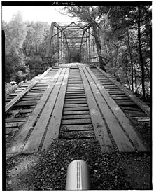
Little Missouri River Bridge
- Little Missouri River Bridge
-
Little Missouri River Bridge
Die Little Missouri River Bridge (auch bekannt als Nachitoch Bluff Bridge) ist eine historische ehemalige Straßenbrücke, die Clark County und Nevada County im US-Bundesstaat Arkansas, Vereinigten Staaten verband. Sie befindet sich unweit von Prescott auf der County Road 479 (Bunn Road), flussaufwärts des Little Missouri River, abseits des Interstate 30. Der Architekturstil ist in Truss bridge gehalten. Die Brücke überspannt den Little Missouri River.
Die Little Missouri River Bridge wurde zwischen 1907 und 1910 von der Morava Construction Company aus Chicago errichtet und 1980 saniert. 1996 wurde die Brücke komplett außer Betrieb genommen. Die durchschnittliche Fahrzeugüberquerung betrug 23 Meter (letzter Stand 1987). Die Gesamtspannweite der Brücke beträgt 53,9 Meter, ihre Gesamtlänge 95,4 Meter. Die innere Breite beträgt 4,4 Meter und die vertikale Höhe 4,25 Meter. Das Fundament besteht aus Stahl, weitere Baustoffe der Brücke sind Beton und Stahl.
Die Little Missouri River Brücke wurde am 9. April 1990 vom National Register of Historic Places mit der Nummer 90000536 als historisches Denkmal registriert.[1][2][3]
Weblinks
Einzelnachweise
- ↑ NRIS
- ↑ HISTORIC AMERICAN ENGINEERING RECORD LITTLE MISSOURI RIVER BRIDGE HAER NO. AR-44
- ↑ Historic Bridge Program
33.90283-93.30985
Kategorien:
- Denkmal im National Register of Historic Places (Arkansas)
- Brücke in Arkansas
- Erbaut in den 1900er Jahren
Wikimedia Foundation.
Schlagen Sie auch in anderen Wörterbüchern nach:
Missouri River — Coordinates: 38°48′49″N 90°07′11″W / 38.81361°N 90.11972°W / 38.81361; 90.11972 … Wikipedia
Little Niangua Suspension Bridge — The Little Niangua Suspension Bridge is a Little Niangua River crossing in Camden County, Missouri on Route J. It is a two lane heavy vehicle bridge. History The bridge was constructed in 1933 by the Clinton Bridge Works. It was designed as a… … Wikipedia
2011 Missouri River floods — Corps of Engineers photo of June 16, 2011, showing the Fort Calhoun nuclear power plant surrounded by flood water … Wikipedia
Battle of Little Blue River — Infobox Military Conflict conflict=Battle of Little Blue River partof=American Civil War date=October 21, 1862 place=Five miles east of Independence, Missouri result=Confederate victory combatant1= flagicon|USA|1863 United States (Union)… … Wikipedia
DXN Bridge over Missouri River — U.S. National Register of Historic Places … Wikipedia
Upper Missouri River Breaks National Monument — This article is about the location. For the film, see The Missouri Breaks. Upper Missouri River National Monument IUCN Category III (Natural Monument) … Wikipedia
river — river1 riverless, adj. riverlike, adj. /riv euhr/, n. 1. a natural stream of water of fairly large size flowing in a definite course or channel or series of diverging and converging channels. 2. a similar stream of something other than water: a… … Universalium
Missouri State Capitol — showing the Missouri River in the background The Missouri State Capitol is located in the U.S. state of Missouri. Housing the Missouri General Assembly, it is located in the state capital of Jefferson City at 201 West Capitol Avenue. The domed… … Wikipedia
Little Bighorn Battlefield National Monument — IUCN Category III (Natural Monument) … Wikipedia
Missouri — This article is about the U.S. state of Missouri. For the river, see Missouri River. For other uses, see Missouri (disambiguation). State of Missouri … Wikipedia

