- Chatturat
-
Chatturat
จัตุรัสProvinz: Chaiyaphum Fläche: 731.0 km² Einwohner: 74,548 (2000) Bev.dichte: 102.0 E./km² PLZ: 36130 Geocode: 3606 Karte 
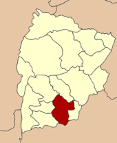
Amphoe Chatturat (Thai:อำเภอ จัตุรัส) ist ein Landkreis (Amphoe - Verwaltungs-Distrikt) im Süden der Provinz Chaiyaphum. Die Provinz Chaiyaphum liegt in der Nordostregion von Thailand, dem so genannten Isaan.
Inhaltsverzeichnis
Geographie
Die Nachbarbezirke sind im Uhrzeigersinn von Norden startend: die Amphoe Ban Khwao, Noen Sa-nga der Provinz Chaiyaphum, Phra Thong Kham und Dan Khun Thot der Provinz Nakhon Ratchasima sowie die Amphoe Bamnet Narong, Sap Yai und Nong Bua Rawe, wiederum zu Chaiyaphum gehörend.
Chatturat ist flach. Im Tambon Lahaan befindet sich der Stausee Don La Nam.
Geschichte
Phraya Narin Songkhram gründete Chatturat mit Auswanderern von Vientiane im heutigen Joho, Nakhon Ratchasima. 1826 verlegte Phraya Narin Songkhram die Siedlung in das fruchtbare Gebiet in der heutigen Provinz Chaiyaphum.
Verwaltung
The Distrikt ist in 9 Gemeinden (Tambon) unterteilt, die wiederum aus 115 Dörfern (Muban) bestehen .
Es gibt auch zwei Kleinstädte (Thesaban Tambon) im Landkreis:
- Chatturat (Thai: เทศบาลตำบลจัตุรัส) besteht aus Teilen des Tambon Ban Kok,
- Nong Bua Khok (Thai: เทศบาลตำบลหนองบัวโคก) besteht aus Teilen des Tambon Nong Bua Khok.
Außerdem gibt es neun „Tambon Administrative Organizations“ (TAO, องค์การบริหารส่วนตำบล – Verwaltungs-Organisationen).
Nr. Name Thai Muban 1. Ban Kok บ้านกอก 17 2. Nong Bua Ban หนองบัวบาน 10 3. Ban Kham บ้านขาม 12 5. Kut Nam Sai กุดน้ำใส 14 6. Nong Don กุดน้ำใส 11 7. Lahaan ละหาน 18 10. Nong Bua Yai หนองบัวใหญ่ 9 11. Nong Bua Khok หนองบัวโคก 11 13. Sompoi ส้มป่อย 13 Weblinks
Amphoe der Provinz ChaiyaphumMueang Chaiyaphum | Ban Khwao | Khon Sawan | Kaset Sombun | Nong Bua Daeng | Chatturat | Bamnet Narong | Nong Bua Rawe | Thep Sathit | Phu Khiao | Ban Thaen | Kaeng Khro | Khon San | Phakdi Chumphon | Noen Sa-nga | Sap Yai
15.565555555556101.84555555556Koordinaten: 15° 34′ N, 101° 51′ O
Wikimedia Foundation.

