Newport (New South Wales)

Newport (New South Wales)
Newport
Newport NSW Australia.jpg
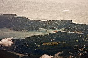
Luftaufnahme von Newport, zwischen Pittswater Bay und Pazifik
Staat: Australien Australien
Bundesstaat: Flag of New South Wales.svg New South Wales
Koordinaten: 33° 39′ S, 151° 19′ O-33.65151.31666666667Koordinaten: 33° 39′ S, 151° 19′ O
 
Einwohner: 9.227 (2006) [1]
 
Zeitzone: AEST (UTC +10)
LGA: Pittwater Council
Newport (Australien)
Newport
Newport

Newport ist ein Vorort im Norden Sydneys in New South Wales, Australien. Newport liegt 31 Kilometer nördlich des Stadtzentrums im Verwaltungsgebiet (LGA) Pittwater Council.
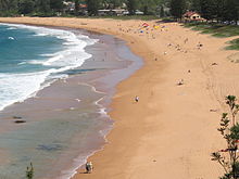
Strand von Newport

Im Jahr 1880 wurde diese Gegend zum ersten Mal Newport genannt, als Charles Jeannerett und George Pile auf der Landzunge eine Werft und das Newport Hotel errichteten. Jeannerett machte Tagesausflüge, entweder per Kutsche von Manly oder mit dem Schiff von Sydney, populär. Mit zunehmender Besucherzahl wurde der Ort größer und es kamen neue Häuser, vor allem in Strandnähe, hinzu. Noch ein den 1920er und 1930er Jahren war Newport lediglich ein Ferien- und Ausflugsziel, viele Gebäude standen die meiste Zeit des Jahres leer. Erst um 1950 wurde es zum Vorort von Sydney.[2]

Weblinks

 Commons: Newport, New South Wales – Sammlung von Bildern, Videos und Audiodateien

Einzelnachweise

  1. Australian Bureau of Statistics (25. Oktober 2007): Newport (State Suburb) (Englisch). 2006 Census QuickStats. Abgerufen am 28. Dezember 2010.
  2. Pittwaters Vergangenheit - Newport. Mona Vale Library, abgerufen am 28. Dezember 2010 (englisch).

Wikimedia Foundation.

Игры ⚽ Нужно сделать НИР?

Schlagen Sie auch in anderen Wörterbüchern nach:

  • Newport, New South Wales — Newport New South Wales Newport beach Population: 9,227 …   Wikipedia

  • New South Wales 422 class locomotive — New South Wales 422 class Australian Railroad Group operated locomotive (now renumbered 2208) at Newport, Victoria. Power type Diesel electric Builder Clyde Engineering Co.Pt …   Wikipedia

  • New South Wales Suburban Rugby Union — The New South Wales Suburban Rugby Union (NSWSRU) is affiliated to the New South Wales Rugby Union and runs the competition affectionately known as Subbies rugby. There are around 7500 players and 55 clubs competing across 6 divisions, making… …   Wikipedia

  • New South Wales Waratahs — Waratahs Waratahs Généralités Nom complet …   Wikipédia en Français

  • Clareville, New South Wales — Clareville Sydney, New South Wales Clareville Beach Postcode: 2107 …   Wikipedia

  • Coogee, New South Wales — Coogee Sydney, New South Wales Coogee Beach, view from Dolphin Point at the northern end …   Wikipedia

  • Maroubra, New South Wales — For the New South Wales Legislative Assembly Electorate, see Electoral district of Maroubra. Maroubra Sydney, New South Wales Maroubra Beach …   Wikipedia

  • Bilgola, New South Wales — Infobox Australian Place | type = suburb name = Bilgola city = Sydney state = NSW caption = lga = Pittwater Council postcode = est = pop = area = propval = stategov = Pittwater fedgov = Mackellar near nw = Avalon near n = Avalon near ne = near w …   Wikipedia

  • Bayview, New South Wales — Infobox Australian Place | type = suburb name = Bayview city = Sydney state = NSW caption = Bayview at Dusk lga = Pittwater postcode = 2104 est = pop = area = stategov = Pittwater fedgov = Mackellar near nw = Church Point near n = Scotland Island …   Wikipedia

  • Eraring, New South Wales — Infobox Australian Place | type = suburb name = Eraring city = state = nsw caption = lga = City of Lake Macquarie postcode = 2264 pop = 212 (2006 census) area = est = 1840 parish = Coorumbung stategov = Lake Macquarie fedgov = Charlton dist1 = 7… …   Wikipedia

Share the article and excerpts

Direct link
Do a right-click on the link above
and select “Copy Link”