- Chislehurst
-
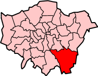
London Borough of Bromley 
Lage in Greater LondonStatus London Borough Region Greater London Verwaltungssitz Bromley Fläche 150,15 km² (211.) Einwohner (2007) 300.700 (18.) ONS-Code 00AF Website www.bromley.gov.uk London Borough of Bromley [ˈbɹɒmli] ist ein Stadtbezirk von London und liegt im Südosten der Stadt. Er ist der flächenmäßig größte Stadtbezirk und wurde bei der Gründung von Greater London im Jahr 1965 aus folgenden Gemeinden der Grafschaft Kent gebildet: Bromley, Beckenham, Penge, Orpington sowie ein Teil von Chislehurst and Sidcup. 1969 wurde das Dorf Knockholt abgetrennt und dem Distrikt Sevenoaks in Kent hinzugefügt.
Wegen der ausgedehnten Grünflächen und Landwirtschaftszonen im Südteil gilt Bromley als der ländlichste Bezirk Londons. Neuwied ist Partnerstadt. Die Bevölkerung setzt sich aus folgenden Ethnien zusammen: 91,6 % Weiße, 2,6 % Südasiaten und 2,9 % Schwarze.
Der bei der gleichnamigen Ortschaft gelegene Biggin Hill Airport ist mit ca. 90.000 Flügen pro Jahr[1] ein wichtiger Standort der Geschäftsluftfahrt im Raum London.
Inhaltsverzeichnis
Stadtteile
- Anerley
- Beckenham
- Bickley
- Biggin Hill
- Bromley
- Bromley Common
- Chelsfield
- Chislehurst
- Downe
- Elmstead
- Farnborough
- Green Street Green
- Hayes
- Keston
- Kevington
- Mottingham
- Orpington
- Penge
- Petts Wood
- Pratt's Bottom
- Shortlands
- Southborough
- St Mary Cray
- St Paul's Cray
- Sundridge
- West Wickham
Persönlichkeiten
- Enid Blyton, Kinderbuchautorin
- Napoléon III., Kaiser der Franzosen
- Napoléon Eugène Louis Bonaparte, Sohn des Obigen
- Eugénie, Kaiserin der Franzosen
- Wilfred Baddeley - Tennisspieler
- Andy Bown - Musiker (Status Quo, The Herd)
- Malcolm Campbell - Rennfahrer
- Norman Cook - Musiker ("Fatboy Slim")
- Charles Darwin - Naturforscher
- Peter Frampton - Musiker
- Nick Heyward - Musiker
- Nic Jones - Folkmusiker
- Derek Lamb - Dokumentar- und Trickfilmer
- Gary Paffett - Rennfahrer
- Stephen Peet - Dokumentarfilmer
- Richard Reid - Terrorist
- Talbot Rothwell - Schriftsteller und Drehbuchautor
- Steven Severin - Bassist von Siouxsie and the Banshees
- Siouxsie Sioux - Sängerin von Siouxsie and the Banshees
- David Sylvian - Musiker
- Francis Walsingham - Begründer des britischen Geheimdienstes
- Joe Wheeler - Musikforscher
- Alexander Wichert - deutscher Schriftsteller
- Bill Wyman - Bassist der Rolling Stones
- H. G. Wells - englischer Schriftsteller
Weblinks
- Bromley Borough Council (Bezirksverwaltung)
Quellen
- ↑ Biggin Hill Airport - General Information (engl.; PDF-Format; Stand: Mai 2006)
Stadtbezirke von LondonBarking and Dagenham | Barnet | Bexley | Brent | Bromley | Camden | City of London | City of Westminster | Croydon | Ealing | Enfield | Greenwich | Hackney | Hammersmith and Fulham | Haringey | Harrow | Havering | Hillingdon | Hounslow | Islington | Kensington and Chelsea | Kingston | Lambeth | Lewisham | Merton | Newham | Redbridge | Richmond | Southwark | Sutton | Tower Hamlets | Waltham Forest | Wandsworth
Sonstige Einteilung: Greater London | Inner London | Outer London | County of London
Wikimedia Foundation.