- Smith Rock State Park
-
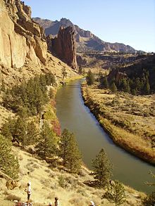
 Der Crooked River im Smith Rock State Park
Smith Rock ist ein State Park im Deschutes County des US-Bundesstaates Oregon. Der 1959 gegründete[1], 2,6 Quadratkilometer große Park liegt 14 Kilometer nordöstlich von Redmond.
Der Park schützt einen Höhenzug von vielfarbigen Felsspitzen, die über dem Crooked River in der High Desert in Oregon aufragen. Die Felsen aus Tuffstein sind vulkanischen Ursprung und erreichen eine Höhe von bis zu 167 Meter, die Höchste Erhebung beträgt 1024 Meter über NN. Berühmt ist der Monkey Face, eine über 100 Meter hohe Felssäule mit Überhängen auf allen Seiten in der Form eines Affenkopfs.
Benannt wurden die Felsen nach dem Pionier John Smith, der sie 1867 entdeckt haben soll. Nach einer anderen Legende sind sie nach einem Soldaten namens Smith benannt, der hier in den 1860er Jahren tödlich verunglückte. An Wildtieren kann man Maultierhirsche, Goldadler, Präriefalken, und viele weitere Vogelarten, wie zum Beispiel Lazulifinken beobachten[2], schwieriger zu sehen sind Gelbbauchmurmeltiere oder Fledermäuse.
Die Benutzung des Parks ist gebührenpflichtig. Der Park gilt mit als Geburtsort des Sportkletterns in den USA[3]. Heute ist er mit über 1800 Kletterrouten ist er ein international bekanntes Ziel für Sportklettern. Durch den Park führen auch Reitwege, Mountain-Biketrails und insgesamt sieben Kilometer Wanderwege. Am Parkeingang befinden sich ein Picknickplatz und ein einfacher Zeltplatz.
Der Park diente mehrfach als Filmkulisse, z.B. für den Western Mit Dynamit und frommen Sprüchen mit John Wayne oder für den Film Postman von und mit Kevin Costner[4]
Literatur
Jan Bannan: Oregon State Parks: A complete Recreation Guide. Seattle: Mountaineer Books, 2. Auflage 2002, ISBN 978-0-89886-794-7
Weblinks
-
 Commons: Smith Rock State Park – Sammlung von Bildern, Videos und Audiodateien
 - Internetpräsenz des State Parks
- Internetseite mit Kletterrouten (engl.)
- Smith Rock State Park im Geographic Names Information System des United States Geological Survey
Einzelnachweise
- ↑ oregonencyclopedia.org. Abgerufen am 5. April 2011.
- ↑ Smith Rock. Abgerufen am 5. April 2011.
- ↑ Smith Rock 1986: The Birth of U.S. Sport Climbing. Abgerufen am 2. Mai 2011.
- ↑ What to see in Central Oregon: Travel Destination Smith Rock State Park. Abgerufen am 2. Mai 2011.
44.367156-121.140306810-1024Koordinaten: 44° 22′ 1,8″ N, 121° 8′ 25,1″ WKategorie:- State Park in Oregon
-
Wikimedia Foundation.
