Tanjung Piai

Tanjung Piai
1.2658333333333103.51111111111
Tanjung Piai (Malaysia)
Tanjung Piai
Tanjung Piai

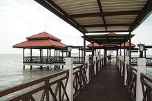
Tanjung Piai ist ein Kap in Malaysia und der südlichste Punkt des asiatischen Festlandes. Es befindet sich im Distrikt Pontian des Bundesstaates Johor.

Tanjung Piai jeti1.jpg

Tanjung Piai liegt an der Südspitze der Malaiischen Halbinsel westlich von Singapur und etwa 35 km Luftlinie südwestlich von Johor Bahru. Im Westen befindet sich das südöstliche Ende der Straße von Malakka, im Südosten der Eingang zur Straße von Singapur und im Nordosten der Eingang zur Straße von Johor.

Das Kap ist eingebettet in den 1971 eingerichteten 926 Hektar großen Nationalpark Tanjung Piai, der zum Großteil aus Mangrovenwäldern besteht.

Weblinks


Wikimedia Foundation.

Игры ⚽ Поможем решить контрольную работу

Schlagen Sie auch in anderen Wörterbüchern nach:

  • Tanjung Piai — es un cabo en la provincia de Johor, en Malasia, el cual constuye el extremo meridional de Malasia Peninsular y por ende el extremo sur de Asia continental. La silueta de Singapur se puede ver detrás del estrecho de Johor. Está rodeado por… …   Wikipedia Español

  • Tanjung Piai — is a cape in Johor which is the southernmost point of Peninsular Malaysia and thus the most southern point of mainland Asia. The skyline of Singapore is visible across the Johor Strait from the point. It features seafood restaurants, perched on… …   Wikipedia

  • Mangroves of the Straits of Malacca — The Mangroves of the Straits of Malacca are found along the coast of Singapore, Thailand, and Northern Sumatra. These tropical mangrove forests are highly diverse, and are important wetlands with high conservation values. There are two Ramsar… …   Wikipedia

  • Protected areas of Johor — The state of Johor in Malaysia is noted for its national parks and forest reserves which preserve virgin rainforests known for its biodiversity and endangered species of animals. Mangrove swamps and coral reefs are also protected within these… …   Wikipedia

  • Second Link Expressway — E3 Expressway Second Link Expressway Route information Maintained by PLUS Expressway Berhad and Linkedua Malaysia Berhad Length …   Wikipedia

  • List of lighthouses in Malaysia — Malaysia is a country largely surrounded by large bodies of water, most notably by the Strait of Malacca and the South China Sea that are used extensive for international shipping since the 15th century. Over time, numerous lighthouses were… …   Wikipedia

  • Johor — Subdivisions of Malaysia native name=جوهر دارالتّعظيم Johor Darul Ta zim conventional long name= state motto= Kepada Allah Berserah state anthem= Lagu Bangsa Johor common name=Johor capital=Johor Bahru royal capital=Pasir Pelangi1… …   Wikipedia

  • Masai, Johor — Masai Masai main street …   Wikipedia

  • Nusajaya — 努沙再也 னுஸஜய City Country Malaysia State …   Wikipedia

  • Iskandar Malaysia — Iskandar Malaysia, formerly known as Iskandar Development Region (IDR) and South Johor Economic Region (SJER) is the new main southern development corridor in Johor, Malaysia. The Iskandar Malaysia was established on 30 July 2006. It is named… …   Wikipedia

Share the article and excerpts

Direct link
Do a right-click on the link above
and select “Copy Link”