Vanua Vatu

Vanua Vatu
Vanua Vatu
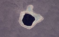
NASA-Bild von Vanua Vatu
Gewässer Korosee
Inselgruppe Lau-Inseln
Geographische Lage 18° 22′ 15″ S, 179° 16′ 16″ W-18.370833333333-179.2711111111194Koordinaten: 18° 22′ 15″ S, 179° 16′ 16″ W
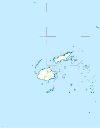
Vanua Vatu (Fidschi)
Vanua Vatu
Länge 2,2 km
Breite 2 km
Fläche 3,5 km²
Höchste Erhebung 94 m
Hauptort Vanuavatu

Vanua Vatu [βaˈnua βatu] ist eine Insel vulkanischen Ursprungs im Zentrum des Lau-Archipels im Pazifischen Ozean. Politisch gehört sie zur Eastern Division des Inselstaates Fidschi.

Geographie

Vanua Vatu liegt vergleichsweise isoliert in der Korosee, rund 55 km westlich von Lakeba, der Hauptinsel des Archipels, 65 km südwestlich von Nayau, sowie 70 km südlich von Cicia. Die annähernd quadratische Insel hat eine Länge von 2,2 km, eine Breite von 2 km und weist eine Fläche von etwa 3,5 km² auf. Sie ist vollständig von einem Korallenriff umsäumt, dicht bewaldet und erreicht eine Höhe von 92 m über dem Meer.[1] Die Insel ist bewohnt und hat mit Vanuavatu nur ein Dorf,[2] welches zum traditionellen Distrikt (Tikina) der Insel Totoya, 82 km südwestlich gelegen, gehört.

Einzelnachweise

  1. Sailing Directions (enroute), Pub. 126, Pacific Ocean (PDF; englisch)
  2. Eintrag bei geonames.org (englisch)

Wikimedia Foundation.

Игры ⚽ Поможем написать курсовую

Schlagen Sie auch in anderen Wörterbüchern nach:

  • Vatu Vara — Island lies in the northwest sector of Fiji s northern Lau Group of islands, 32km west of Mago Island and some 60 km south west of Vanua Balavu at Lat: 17° 26 00 S Long: 179° 31 00 W. The island is 3km in diameter at the base of its 305m high… …   Wikipedia

  • Namalata — is a village and its own island but is part of the Island Group of Vanua Balavu in Fiji s Lau archipelago. Namalata is part of Lomaloma Tikina. The people of Namalata were the original inhabitants of Mago Island, which is now owned by the actor… …   Wikipedia

  • Mago Island — Coordinates: 17°26′S 179°09′W / 17.433°S 179.15°W / 17.433; 179.15 …   Wikipedia

  • Liste Des Îles Fidji — Les Îles Fidji sont un ensemble archipélagique de près de 100 îles habitées. Sommaire 1 Viti Levu et îles adjacentes 2 Vanua Levu, Taveuni et îles adjacentes 3 Archipel Lomaiviti …   Wikipédia en Français

  • Liste des iles Fidji — Liste des îles Fidji Les Îles Fidji sont un ensemble archipélagique de près de 100 îles habitées. Sommaire 1 Viti Levu et îles adjacentes 2 Vanua Levu, Taveuni et îles adjacentes 3 Archipel Lomaiviti …   Wikipédia en Français

  • Liste des îles Fidji — Les Îles Fidji sont un ensemble archipélagique de près de 100 îles habitées. Sommaire 1 Viti Levu et îles adjacentes 2 Vanua Levu, Taveuni et îles adjacentes 3 Archipel Lomaiviti …   Wikipédia en Français

  • Liste des îles fidji — Les Îles Fidji sont un ensemble archipélagique de près de 100 îles habitées. Sommaire 1 Viti Levu et îles adjacentes 2 Vanua Levu, Taveuni et îles adjacentes 3 Archipel Lomaiviti …   Wikipédia en Français

  • Liste des îles des Fidji — Les Fidji sont un archipel composé d une centaine d îles habitées. Sommaire 1 Viti Levu et îles adjacentes 2 Vanua Levu, Taveuni et îles adjacentes 3 Archipel Lomaiviti …   Wikipédia en Français

  • Cicia —   Island   …   Wikipedia

  • Ogea Levu — (pronounced [oˈŋea ˈleβu]) is a coral island on a barrier reef in Fiji s Southern Lau archipelago. With an area of 13.3 square kilometers, it is situated at 19.18° South and 178.47° East, 10 kilometers east of Fulaga. It has a maximum altitude of …   Wikipedia

Share the article and excerpts

Direct link
Do a right-click on the link above
and select “Copy Link”