Vatoa

Vatoa
Vatoa
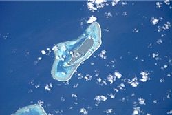
NASA-Bild von Vatoa Am unteren Bildrand ist der Nordteil von Vuata Vatoa zu erkennen
NASA-Bild von Vatoa
Am unteren Bildrand ist der Nordteil von Vuata Vatoa zu erkennen
Gewässer Pazifischer Ozean
Inselgruppe Lau-Inseln
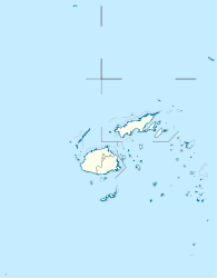
Geographische Lage 19° 49′ 15″ S, 178° 14′ 40″ W-19.820833333333-178.2444444444467Koordinaten: 19° 49′ 15″ S, 178° 14′ 40″ W
Vatoa (Fidschi)
Vatoa
Länge 4,2 km
Breite 1,4 km
Fläche 4,45 km²
Höchste Erhebung 67 m
Einwohner 300
67 Einw./km²
Hauptort Vatoa

Vatoa ist eine Insel im äußersten Südosten der zu Fidschi gehörenden Lau-Inseln. Die Insel ist rund 4 km lang, bis zu 1,5 km breit und stellt die zentrale, bis 67 m hohe[1] Insel des gleichnamigen Atolls dar. Vatoa hat rund 300 Bewohner und stellt somit nach Ono-i-Lau die zweitsüdlichste, bewohnte Landmasse Fidschis dar. Die gesamte Insel besteht aus Kalkstein des Miozäns. Nur wenige Kilometer südwestlich befindet sich das ringförmige Korallenriff Vuata Vatoa.

Vatoa ist die einzige Insel Fidschis, die jemals von James Cook angefahren wurden. Als Cook das Eiland am zweiten Juli 1774 entdeckte, wurde er von einigen Einheimischen empfangen, mit denen er Waren tauschte. Da Cook einige Schildkröten auf einem Riff in der Nähe des Eilands sah, verzeichnete er Vatoa in seinen Seekarten als Schildkröten-Insel.

Die Insel hat für diese Region der Südsee, durch das häufige Auftreten von Passat-Winden, relativ kaltes Wetter.

Am höchsten Punkt von Vatoa finden sich Überreste von alten Befestigungsanlagen.

Einzelnachweise

  1. National Geospatial-Intelligence Agency: Sailing Directions (enroute), Pub. 126, Pacific Ocean (englisch; PDF) (Abgerufen am 30. September 2010)

Wikimedia Foundation.

Игры ⚽ Нужно решить контрольную?

Schlagen Sie auch in anderen Wörterbüchern nach:

  • Vatoa — (pronounced|βatoa) (known as Turtle Island after Cook s visit) is an outlier of Fiji s Lau Group.Vatoa was the only island of present day Fiji visited by James Cook. The island was sighted on 2 July 1774. Next day, Sunday July 3, the Master and… …   Wikipedia

  • Vuata Vatoa — Vorlage:Infobox Insel/Wartung/Höhe fehlt Vuata Vatoa Gewässer Pazifischer Ozean Archipel Lau Inseln Geographische Lage …   Deutsch Wikipedia

  • Ono-i-Lau — NASA picture of Ono i Lau. Ono i Lau is a volcanic and coral island in Fiji s Lau archipelago. One of the southernmost of the Lau Islands, it is located at 20.80° South and 178.75° East, and occupies an area of 7.9 square kilometers. It has a… …   Wikipedia

  • Ватоа — фидж. Vatoa …   Википедия

  • Lauanische Sprache — Lauanisch (Lau) Gesprochen in Fidschi (Inseln Lau, Nayau, Lakeba, Oneata, Moce, Komo, Namuka, Kabara, Vulaga, Ogea und Vatoa) Sprecher 16.000 (1981)[1] Linguistische Klassifikation Austronesian …   Deutsch Wikipedia

  • Ono-i-Lau — Vorlage:Infobox Insel/Wartung/Höhe fehlt Ono i Lau Satellitenbild von Ono i Lau Gewässer Pazifischer Ozean Archipel …   Deutsch Wikipedia

  • Geography of Fiji — Fiji closeup map (not included: Ceva i Ra in the southwest and Rotuma in the north …   Wikipedia

  • Fijian language — Fijian Na vosa vaka Viti Spoken in  Fiji Region Spoken as first language on …   Wikipedia

  • List of Fiji-related articles — NOTOC Articles (arranged alphabetically) about people, places, things, and concepts related to or originating from Fiji, include: 0 9 2007 Colonial Cup A Rodney ACRAMAN Adi Adi Da James AH KOY Air Fiji Air Pacific Air Pacific destinations Ahmed… …   Wikipedia

  • Mago Island — Coordinates: 17°26′S 179°09′W / 17.433°S 179.15°W / 17.433; 179.15 …   Wikipedia

Share the article and excerpts

Direct link
Do a right-click on the link above
and select “Copy Link”