Warwick Junction

Warwick Junction

p1

Warwick Junction
Warwick Junction (Neuseeland)
Warwick Junction
Koordinaten 42° 8′ S, 172° 14′ O-42.133888888889172.23577777778Koordinaten: 42° 8′ S, 172° 14′ O
Region West Coast
Distrikt Buller-Distrikt

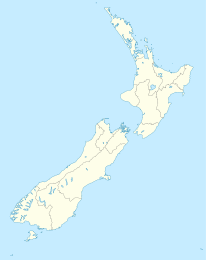
Warwick Junction ist eine kleine Ortschaft im Buller-Distrikt in der Region West Coast im Norden der Südinsel Neuseelands. Der State Highway 65 passiert den Ort. Nachbarorte sind Maruia im Süden und Burbrae im Süden.

Die Siedlung besteht aus wenigen verstreut liegenden Häusern beidseits des Flusses, der hier von einer Straßenbrücke überquert wird. Der Warwick River mündet hier in den Maruia.

Westlich des Ortes befindet sich die im Victoria Forest Park gelegene Gebirgskette Victoria Range mit mehreren über 1500 m hohen Gipfeln, östlich des Tales verläuft ein Ausläufer der Spenser Mountains.

Einzelnachweise


Wikimedia Foundation.

Игры ⚽ Нужен реферат?

Schlagen Sie auch in anderen Wörterbüchern nach:

  • Warwick, New York —   Town   …   Wikipedia

  • Warwick Avenue tube station — is a London Underground station near Little Venice in inner north west London. The station is on the Bakerloo line, between Paddington and Maida Vale stations, and is in Travelcard Zone 2. Warwick Avenue opened on 31 January 1915 on the Bakerloo… …   Wikipedia

  • Warwick Mall — is an enclosed shopping mall in Warwick, Rhode Island, on the northside of Interstate 295 near the junction of Interstate 95. Composed of more than convert|1000000|sqft|m2| 5|sing=on of retail space, it features more than 70 stores and a food… …   Wikipedia

  • Warwick Village Historic District — Infobox nrhp name = Warwick Village Historic District nrhp type = hd caption = Old Masonic temple and shops along Main Street, 2008 lat degrees = 41 lat minutes = 15 lat seconds = 23 lat direction = N long degrees = 74 long minutes = 21 long… …   Wikipedia

  • Warwick Castle — Infobox Historic building caption=View of the east façade from the River Avon name=Warwick Castle location town=Warwick, Warwickshire location country=England map type=Warwickshire latitude=52.2793 longitude= 1.585 architect= client=Henry de… …   Wikipedia

  • Salford Junction — (gbmapping|SP095901) is the name of the junction where the Grand Union Canal and Tame Valley Canal meet the Birmingham and Fazeley Canal north of Birmingham, England.One of the Birmingham terminations of the Grand Union Canal (originally here… …   Wikipedia

  • Bordesley Junction — (gbmapping|SP084864) is a canal junction where the Grand Union Canal splits near to Bordesley, Birmingham, England.The southern arm is the main line of the Grand Union to London. The north east arm was originally the Birmingham and Warwick… …   Wikipedia

  • Grand Junction Canal — The Grand Junction Canal is a canal in England from Braunston in Northamptonshire to the River Thames at Brentford, with a number of branches. The mainline was built between 1793 and 1805, to improve the route from the Midlands to London, by… …   Wikipedia

  • Manchester, South Junction and Altrincham Railway — Route map of the Manchester South Junction Altrincham Railway, showing the layout of connecting lines in the Manchester area (click for full size view) The Manchester South Junction and Altrincham Railway (MSJ AR) was a suburban railway which… …   Wikipedia

  • Kingswood Junction — (gbmapping|SP185709) is a series of canal junctions where the Stratford upon Avon Canal meets the Grand Union Canal at Kingswood, Warwickshire, England.The junction consists of a 250 metre linking arm with two branches at the (western) Stratford… …   Wikipedia

Share the article and excerpts

Direct link
Do a right-click on the link above
and select “Copy Link”