Yeoford

Yeoford
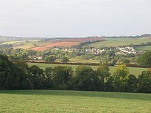
Yeoford im Tal des Yeo

Yeoford ist ein Dorf nahe der Stadt Crediton in Devon in Südwest-England. Namensgebend war der Fluss Yeo, der das Dorf durchfließt. Das Postamt wurde im Zuge von Rationalisierungsmaßnahmen 2008 geschlossen.[1]

Inhaltsverzeichnis

Verkehrsanbindung

Der Bahnhof Yeoford war ein Eisenbahnknoten zwischen der Exeter und Barnstaple verbindenden Tarka Line mit der Dartmoor-Strecke nach Okehampton. Die Tarka Line verkehrt inzwischen wieder, nachdem sie seit 1972 für 30 Jahre geschlossen war.

Grundschule

Die Grundschule des Ortes (Yeoford Community Primary School) existiert seit 1878 und hat zurzeit drei Klassen. Sie hatte von Beginn an gemischte Klassen.[2]

Lokale Verwaltung

Yeoford gehört zur „Mid Devon local authority area“, dessen Verwaltung in Crediton ansässig ist. Historisch ist es Teil des „Crediton Hundred“. Die Telefon-Vorwahl lautet 01363, die Postleitzahl EX17.

Einzelnachweise

  1. http://www.globe-democrat.com/news/2010/sep/02/ex-postmistress-now-an-escort/
  2. http://www.yeoford.devon.sch.uk/index.html
50.7735-3.7281

Wikimedia Foundation.

Игры ⚽ Нужна курсовая?

Schlagen Sie auch in anderen Wörterbüchern nach:

  • Yeoford — is a village in Devon, England. It is served by Yeoford railway station on the Exeter Barnstaple railway line (otherwise known as the Tarka Line).External links …   Wikipedia

  • Yeoford railway station — Infobox UK station name = Yeoford locale = Yeoford borough = Mid Devon latitude = 50.777 longitude = 3.726 code = YEO manager = First Great Western platforms = 1 lowusage0203 = 7,993 lowusage0405 = 6,883 lowusage0506 = 6,848 lowusage0607 = 7,701… …   Wikipedia

  • Crediton railway station — Crediton Location Place Crediton …   Wikipedia

  • Exeter to Plymouth railway of the LSWR — Exeter to Plymouth via Okehampton Meldon Viaduct Overview Status Partly closed Locale …   Wikipedia

  • North Tawton railway station — North Tawton North Tawton station in 1969 Location Place …   Wikipedia

  • Tarka Line — Beginn der Tarka Line (linker Ast) bei Cowley Bridge Junction Kartenausschnitt 1930 …   Deutsch Wikipedia

  • Dartmoor Railway — Coordinates: 50°43′55″N 3°59′46″W / 50.732°N 3.996°W / 50.732; 3.996 …   Wikipedia

  • Tarka Line — Infobox generic color = #efefef name = Tarka Line| img1 = Tarkalinelogo.jpg| lbl1 = Location row1 = Devon, England lbl2 = From row2 = Exeter St Davids lbl3 = To row3 = Barnstaple lbl4 = Distance row4 = convert|39|mi|km|0 lbl5 = Status row5 =… …   Wikipedia

  • Okehampton railway station — Okehampton Location Place Okehampton …   Wikipedia

  • Copplestone railway station — Copplestone Copplestone in 1969 Location …   Wikipedia

Share the article and excerpts

Direct link
Do a right-click on the link above
and select “Copy Link”