- Daet
-
Municipality of Daet Lage von Daet in der Provinz Camarines Norte 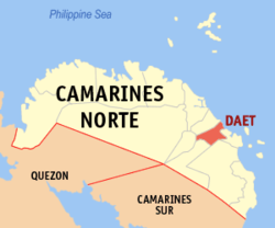
Basisdaten Bezirk: Bicol-Region Provinz: Camarines Norte Barangays: 25 Distrikt: 1. Distrikt von Camarines Norte PSGC: 051603000 Einkommensklasse: 1. Einkommensklasse Haushalte: 16.267 Zensus 1. Mai 2000Einwohnerzahl: 94.184 Zensus 1. August 2007Koordinaten: 14° 7′ N, 122° 57′ O14.116666666667122.95Koordinaten: 14° 7′ N, 122° 57′ O Postleitzahl: 4600 Vorwahl: +63 54 Bürgermeister: Sarte Sarion Offizielle Webpräsenz: Tito Sarte Sarion Geographische Lage auf den Philippinen 

Daet Daet ist eine philippinische Stadtgemeinde in der Provinz Camarines Norte, deren Hauptort sie ist.
Daet ist Sitz des Bistums Daet.
Die Stadtgemeinde ist bei Surfern aus der ganzen Welt ein beliebter Platz zum Surfen, insbesondere der weite Strand Bagasbas. Des Weiteren gehört die Inselgruppe der Calaguas zur Stadtgemeinde.
Baranggays
Daet ist politisch in 25 Baranggays unterteilt.
- Alawihao
- Awitan
- Bagasbas
- Bibirao
- Borabod
- Calasgasan
- Camambugan
- Cobangbang
- Dogongan
- Gahonon
- Gubat
- Lag-on
- Magang
- Mambalite
- Mancruz
- Pamorangon
- Barangay I/Ilaod (Pob.)
- Barangay II/Pasig (Pob.)
- Barangay III/Iraya (Pob.)
- Barangay IV/Mantagbac (Pob.)
- Barangay V/Pandan (Pob.)
- Barangay VI (Pob.)
- Barangay VII (Pob.)
- Barangay VIII/Salcedo (Pob.)
- San Isidro
Tourismus
Aufgrund der Aufmerksamkeit, die Daet von der internationalen Surfergemeinschaft erhalten hat, wurde der Ort vom Ministerium für Tourismus zum international akkreditierten Surfer-Ort erhoben. Darüber hinaus erhält die Inselgruppe Calagua im Norden der Stadtgemeinde Aufmerksamkeit von Touristen aus der Umgebung, genauso wie von ausländischen Touristen. Die Inselgruppe kann als „jungfräulich“ betrachtet werden, da dort noch keine Resorts errichtet wurden.
Weblinks
Stadtgemeinden in der Provinz Camarines NorteStadtgemeinden: Basud | Capalonga | Daet | Jose Panganiban | Labo | Mercedes | Paracale | San Lorenzo Ruiz | San Vicente | Santa Elena | Talisay | Vinzons
Wikimedia Foundation.
Schlagen Sie auch in anderen Wörterbüchern nach:
Daet — Saltar a navegación, búsqueda Banwaan nin Daet Bayan ng Daet Municipio de Daet Mapa de Camarines Norte que muestra la situación de Daet … Wikipedia Español
Daet — Original name in latin Daet Name in other language DTE, Daet, Дает State code PH Continent/City Asia/Manila longitude 14.1122 latitude 122.9553 altitude 10 Population 78142 Date 2011 07 31 … Cities with a population over 1000 database
Daet, Camarines Norte — Map of Camarines Norte showing the location of Daet … Wikipedia
Daet — ► C. y puerto de Filipinas, en la isla de Luzón, cap. de la prov. de Camarines Norte; 54 789 h … Enciclopedia Universal
La Consolacion College-Daet — The La Consolacion College Daet is a Catholic school in Daet in the province of Camarines Norte in the Philippines. The school was founded in 1948 as Daet Parochial School by Monsignor Antonio O. Reganit, the then parish priest of St. John the… … Wikipedia
Pa Daet — ป่าแดด Provinz: Chiang Rai Fläche: 333,3 km² Einwohner: 26.628 (2005) Bev.dichte: 79,9 E./km² PLZ: 57190 … Deutsch Wikipedia
Bistum Daet — Basisdaten Staat Philippinen … Deutsch Wikipedia
Amphoe Pa Daet — Pa Daet ป่าแดด Provinz: Chiang Rai Fläche: 333,3 km² Einwohner: 26.628 (2005) Bev.dichte: 79,9 E./km² PLZ: 57190 … Deutsch Wikipedia
Amphoe Pa Daet — Infobox Amphoe name=Pa Daet thai=ป่าแดด province=Chiang Rai coordinates=coord|19|30|15|N|99|59|35|E|type:adm2nd region:TH capital=Pa Daet area=333.3 population=26,628 population as of=2005 density=79.9 postal code=57190 geocode=5706Pa Daet ( th.… … Wikipedia
Roman Catholic Diocese of Daet — Infobox Diocese| jurisdiction=Diocese name= Daet latin= Dioecesis Daëntiensis country= Philippines | metropolitan=Caceres rite=Latin Rite cathedral = Cathedral of St. John the Baptist cocathedral = area= 2,200 population= 508,360 population as of … Wikipedia
Daet


18+
© Academic, 2000-2026
- Kontaktieren Sie uns: Unterstützung, Werbung
Wörterbücher Export, schritte mit PHP, Joomla, Drupal, WordPress, MODx.