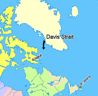
Davis Strait — Davis Strait, lying between Greenland and Nunavut, Canada. Nunavut … Wikipedia
Davis Strait — arm of the Atlantic between Baffin Island, Canada, and W Greenland: c. 200 400 mi (322 644 km) wide … English World dictionary
DAVIS STRAIT — strait connecting Baffin s Bay with the Atlantic, discovered by JOHN DAVIS (q.v. DAVIS, JOHN) … The Nuttall Encyclopaedia
Davis Strait — a strait between Canada and Greenland, connecting Baffin Bay and the Atlantic. 200 500 mi. (320 800 km) wide. * * * Strait, northern Atlantic Ocean. Lying between southeastern Baffin Island and southwestern Greenland, it separates Baffin Bay to… … Universalium
Davis Strait — Da′vis Strait′ n. geg a strait between Canada and Greenland, connecting Baffin Bay and the Atlantic. 200–500 mi. (320–800 km) wide … From formal English to slang
Davis Strait — geographical name strait connecting Baffin Bay with the Atlantic … New Collegiate Dictionary
Davis Strait — /deɪvəs ˈstreɪt/ (say dayvuhs strayt) noun a strait between Canada and Greenland, connecting Baffin Bay and the Atlantic. 320–800 km wide. {named after John Davis1} …
Davis Strait — a strait between Canada and Greenland, connecting Baffin Bay and the Atlantic. 200 500 mi. (320 800 km) wide … Useful english dictionary
Davis Sea — is an area of the sea along the coast of East Antarctica between West Ice Shelf in the west and the Shackleton Ice Shelf in the east[1], or between 82° and 96°E. East of it is Mawson Sea, and in the west is Cooperation Sea. According to the Great … Wikipedia
Strait of Malacca — The Strait of Malacca connects the Pacific Ocean to the east with the Indian Ocean to the west. Coordinates … Wikipedia
 Lage der Davisstraße