- Doi Luang
-
Doi Luang
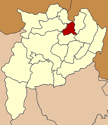
ดอยหลวงProvinz: Chiang Rai Fläche: 223,0 km² Einwohner: 19.356 (2005) Bev.dichte: 86,6 E./km² PLZ: 57110 Geocode: 5718 Karte 
Amphoe Doi Luang (in Thai: อำเภอ ดอยหลวง) ist ein Landkreis (Amphoe - Verwaltungs-Distrikt) im Norden der Provinz Chiang Rai. Die Provinz Chiang Rai liegt im äußersten Norden der Nordregion von Thailand.
Inhaltsverzeichnis
Geographie
Benachbarte Landkreise (von Norden im Uhrzeigersinn): die Amphoe Chiang Saen, Chiang Khong, Wiang Chiang Rung und Mae Chan.
Geschichte
Doi Luang wurde am 15. Juli 1996 als Unterbezirk (King Amphoe) gegründet, bestehend aus Tambon, die von dem Kreis Mae Chan abgespalten wurden.[1] Die thailändische Regierung entschied am 15. Mai 2007, dass alle 81 Unterbezirke den vollen Amphoe-Status erhalten.[2] Diese Entscheidung wurde am 24. August 2007 durch die Veröffentlichung in der Royal Gazette offiziell.[3]
Verwaltung
Der Kreis ist in drei Kommunen (Tambon) eingeteilt, die sich weiter in 31 Dörfer (Muban) unterteilen.
Außerdem gibt es drei „Tambon Administrative Organizations“ (TAO, องค์การบริหารส่วนตำบล - Verwaltungs-Organisationen) im Landkreis.
Nr. Name Thai Dörfer Einw. 1. Pong Noi ปงน้อย 10 5.928 2. Chok Chai โชคชัย 11 8.793 3. Nong Pa Ko หนองป่าก่อ 10 4.635 Einzelnachweise
- ↑ ประกาศกระทรวงมหาดไทย เรื่อง แบ่งเขตท้องที่อำเภอแม่จัน จังหวัดเชียงราย ตั้งเป็นกิ่งอำเภอดอยหลวง. In: Royal Gazette. 113, Nr. พิเศษ 18 ง (Special), 26. Juni 1996, S. 26
- ↑ „แถลงผลการประชุม ครม. ประจำวันที่ 15 พ.ค. 2550 (Thai) “, Manager Online.
- ↑ พระราชกฤษฎีกาตั้งอำเภอฆ้องชัย…และอำเภอเหล่าเสือโก้ก พ.ศ. ๒๕๕๐. In: Royal Gazette. 124, Nr. 46 ก, 24. August 2007, S. 14-21
Weblinks
 Amphoe der Provinz Chiang Rai
Mueang Chiang Rai | Wiang Chai | Chiang Khong | Thoeng | Phan | Pa Daet | Mae Chan | Chiang Saen | Mae Sai | Mae Suai | Wiang Pa Pao | Phaya Mengrai | Wiang Kaen | Khun Tan | Mae Fa Luang | Mae Lao | Wiang Chiang Rung | Doi Luang
20.118333333333100.1Koordinaten: 20° 7′ N, 100° 6′ O
Wikimedia Foundation.