EGAC

EGAC
George Best Belfast City Airport
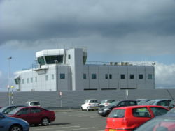
Kenndaten
IATA-Code BHD
ICAO-Code EGAC
Koordinaten
Verkehrsanbindung
Entfernung vom Stadtzentrum 3,2 km von Belfast
Straße
Basisdaten
Eröffnung 1937
Betreiber Ferrovial
Fläche
Passagiere 2.000.000
Start- und Landebahn
04/22 1.829 m × 45 m Asphalt

George Best Belfast City Airport ist der kleinere, stadtnähere der Flughäfen der nordirischen Hauptstadt Belfast. Der Flughafen liegt etwa fünf Kilometer östlich der Innenstadt auf dem großen Hafengelände. Die Firma Bombardier produziert dort.

Name

Am 22. Mai 2006 wurde der Belfast City Airport in George Best Belfast City Airport umbenannt. Belfast ehrt damit den 2005 verstorbenen Weltklasse-Fußballspieler George Best, der an diesem Tag seinen 60. Geburtstag gefeiert hätte.

Weblinks


Wikimedia Foundation.

Игры ⚽ Нужна курсовая?

Schlagen Sie auch in anderen Wörterbüchern nach:

  • EGAC — George Best Belfast City Airport 54°37′05″N 005°52′21″O / 54.61806, 5.8725 …   Wikipédia en Français

  • EGAC — ICAO Airportcode f. Belfast Harbour Airport (United Kingdom) …   Acronyms

  • EGAC — ICAO Airportcode f. Belfast Harbour Airport ( United Kingdom) …   Acronyms von A bis Z

  • Aeropuerto de la Ciudad de Belfast George Best — Belfast City Airport IATA: BHD   OACI: EGAC Sumario Tipo …   Wikipedia Español

  • George Best Belfast City Airport — Infobox Airport name = George Best Belfast City Airport nativename = Belfast City Airport image width = 160 caption = IATA = BHD ICAO = EGAC type = Public owner = Ferrovial operator = Belfast City Airport Ltd. city served = Belfast location =… …   Wikipedia

  • European Gliding Championships — The European Gliding Championships is a gliding competition held every two years or so. Gliding is a competitive sport and was even a demonstration sport at the 1936 Summer Olympics. It was due to become an official Olympic sport in the Helsinki… …   Wikipedia

  • Аэропорт Белфаст-Сити имени Джорджа Беста — Координаты: 54°37′05″ с. ш. 5°52′21″ з. д. / 54.618056° с. ш. 5.8725° з. д …   Википедия

  • East Grinstead — infobox UK place country = England official name = East Grinstead latitude= 51.129 longitude= 0.007 population = 29,000 civil parish = East Grinstead shire district = Mid Sussex shire county = West Sussex region= South East England constituency… …   Wikipedia

  • Taiwan Taoyuan International Airport — 臺灣桃園國際機場 桃園機場 IATA …   Wikipedia

  • NLM CityHopper — IATA HN ICAO NLM Callsign CITY Founded …   Wikipedia

Share the article and excerpts

Direct link
Do a right-click on the link above
and select “Copy Link”