Jazirat at Ta’ir

Jazirat at Ta’ir
Satellitenaufnahme der Insel vor dem letzten Vulkanausbruch (Landsat 7)
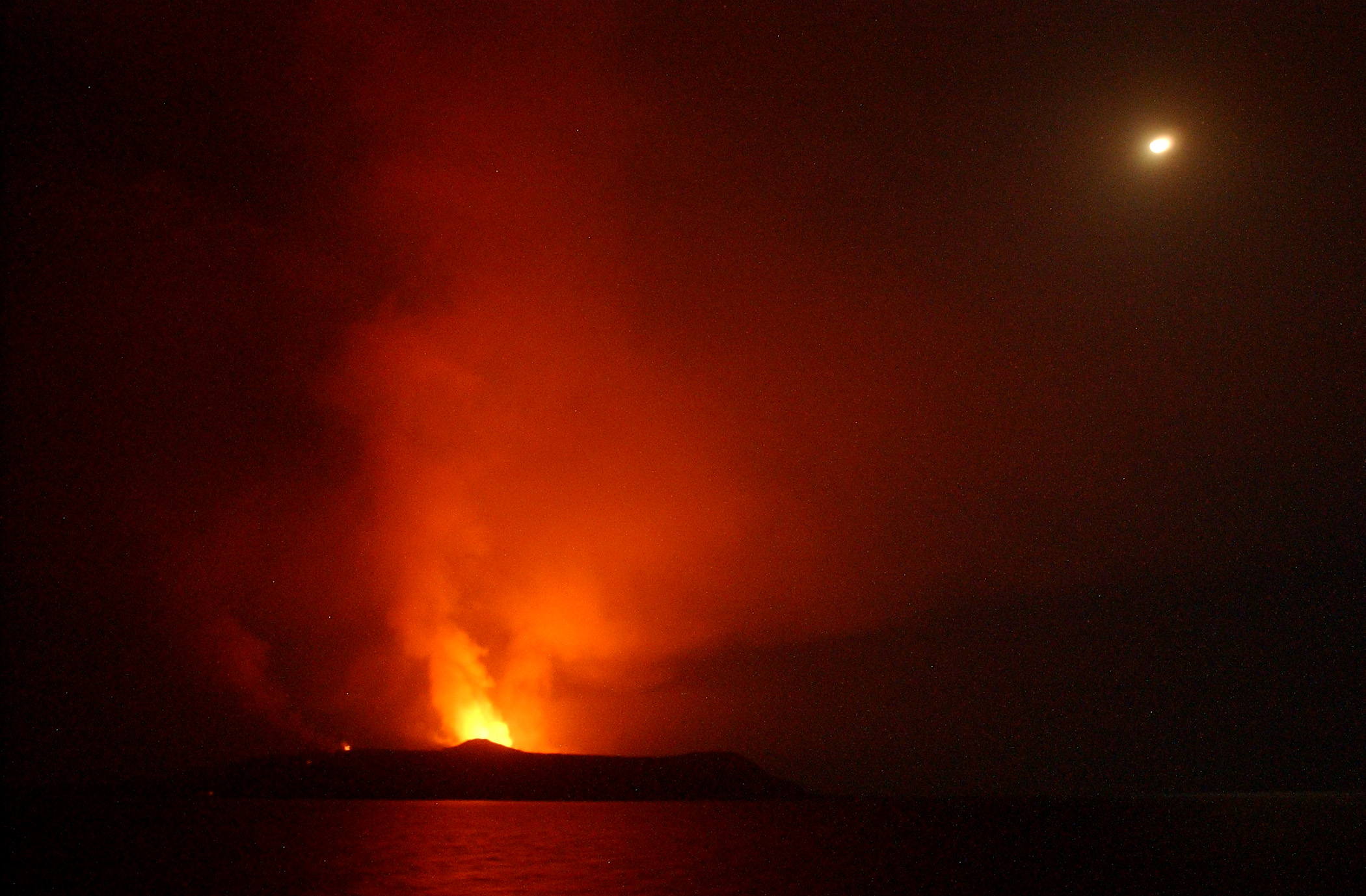
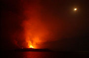
Nächtliche Aufnahme des Ausbruchs 2007 von Bord der USS Bainbridge

Dschazirat Dschabal at-Tair (arabischجزيرة جبل الطير‎ Dschazīrat Dschabal at-Tair, DMG Ǧazīrat Ǧabal aṭ-Ṭayr, „Vogelberginsel“) ist eine kleine Insel vor der Küste des Jemens. Auf der Insel befindet sich ein aktiver Vulkan, der Dschabal at-Ta'ir / ‏جبل الطائر‎ / Ǧabal aṭ-Ṭāʾir (alternative Schreibweisen: Jabal-al-Tair, Jebel at Tair).

Die Insel ist etwa drei Kilometer lang, insgesamt etwa vier Quadratkilometer groß, besitzt eine maximale Höhe von 244 m über dem Meeresspiegel und befindet sich bei den Koordinaten 15,55° Nord und 41,82° Ost. Sie liegt etwa 115 Kilometer vor der jemenitischen Küste im Roten Meer, etwa 100 Kilometer von der jemenitischen Hafenstadt al-Hudaida entfernt. Es handelt sich hierbei um einen Stratovulkan, der aus Basalten besteht und aus einer Tiefe von 1200 Metern emporsteigt. Die Insel ist zumeist von Lavaströmen jüngeren Datums bedeckt.

Am 30. September 2007, 16:00 Uhr GMT, fand auf der Insel ein Vulkanausbruch statt, der von den Schiffen einer nahe liegenden Flotte der Standing NATO Maritime Group 1 beobachtet wurde. Augenzeugen berichteten, dass die ganze Insel glühe. Die Insel war zu diesem Zeitpunkt von einer Militärgarnison der jemenitischen Armee besetzt, ansonsten unbewohnt. Die Regierung des Jemens bat die NATO um Unterstützung bei der Suche nach Überlebenden. Es starben mindestens vier jemenitische Soldaten, 49 Personen konnten gerettet werden. Bereits den ganzen Monat über hatte es Erdbeben auf der Insel gegeben, die zwei Tage vor dem Ausbruch den Höhepunkt mit einem Beben der Stärke 7,3 auf der Richterskala erreicht hatten. Die Insel ist seit dem Ausbruch völlig von Lava, Asche und Geröll bedeckt, der Westteil der Insel ist ins Meer abgesackt.

Der letzte bekannte Ausbruch des Vulkans zuvor hatte im Jahre 1883 stattgefunden.

Weblinks

15.5441.837Koordinaten: 15° 32′ N, 41° 50′ O


Wikimedia Foundation.

Игры ⚽ Нужен реферат?

Schlagen Sie auch in anderen Wörterbüchern nach:

  • Jazirat Bubiyan — is the largest of the several Kuwait islands that lie on the northern tip of the Persian Gulf. It is approximately 2 miles off Kuwait s mainland. [cite web|url=http://land.worldcitydb.com/jazirat bubiyan 493857.html|title=Jazirat Bubiyan World… …   Wikipedia

  • JAZIRAT IBN ʿUMAR — JAZIRAT IBN ʿUMAR, town located N. of mosul in northern iraq . During the reign of the Abbāsid Caliphs and the Crusades, Jazīrat ibn ʿUmar was an important town which maintained close commercial ties with armenia . From the earliest times, a… …   Encyclopedia of Judaism

  • Jazirat-Ul-Arab — Infobox Album Name = Jazirat Ul Arab Type = studio Artist = Muslimgauze Released = 1987 March Recorded = Genre = Length = Label = Limited Editions LIMITED 5 Producer = Reviews = Last album = Hajj (1986) This album = Jazirat Ul Arab (1987) Next… …   Wikipedia

  • Jazirat Badiyah — Infobox Islands name = Jazirat Badiyah image caption = image size = locator map custom = no native name = native name link = nickname = location = coordinates = coord|25|26|N|56|22|E archipelago = total islands = major islands = area = length =… …   Wikipedia

  • Jazirat el Monbastah — Île Plane Phare de l île Plane L île Plane (الجزيرة المنبسطة) est une île rocheuse située au nord de la Tunisie. Elle se trouve dans le prolongement du cap Sidi Ali El Mekki, plus précisément à 2,3 miles de la côte. C est un plateau s élevant de …   Wikipédia en Français

  • Arwād, Jazīrat — ▪ island, Syria Greek  Arados , Phoenician  Arvad        island in the eastern Mediterranean off the Syrian coastal town of Ṭarṭūs. Originally settled by the Phoenicians in the early 2nd millennium BC, it formed an excellent base for their… …   Universalium

  • EZION-GEBER — (Heb. (עֶצְיוֹן גָּבֶר (גֶּבֶר, first mentioned in the Bible as one of the camping sites of the Israelite tribes on their way to Canaan (Num. 33:35–36). As such, it is mentioned next to Elath in Deuteronomy 2:8. From the biblical narrative of the …   Encyclopedia of Judaism

  • Hawar Islands — The Hawar Islands (Arabic: جزر حوار‎; transliterated: Juzur Ḩawār) are a group of islands situated off the west coast of Qatar in the Gulf of Bahrain of the Persian Gulf. Despite their proximity to Qatar (Suwād al Janūbīyah is only 1.4 km… …   Wikipedia

  • Geography of Bahrain — Map of Bahrain Topography …   Wikipedia

  • Sabians — The Sabians ( ar. صابئين, he. צבאים) were a religious group. Most of what is currently known about them comes from what has been written about them by Maimonides and the primary Classical Arabic sources.The Fihrist of Al Nadim, (an Arabic writer… …   Wikipedia

Share the article and excerpts

Direct link
Do a right-click on the link above
and select “Copy Link”