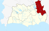
- Amphoe Khao Chamao
-
Khao Chamao
เขาชะเมาProvinz: Rayong Fläche: 269,95 km² Einwohner: 22.432 (2005) Bev.dichte: 83,1 E./km² PLZ: 21110 Geocode: 2107 Karte 
Amphoe Khao Chamao (in Thai: อำเภอ เขาชะเมา) ist ein Landkreis (Amphoe - Verwaltungs-Distrikt) im Nordosten der Provinz Rayong. Die Provinz Rayong liegt in der Ostregion von Zentralthailand.
Inhaltsverzeichnis
Geographie
Benachbarte Distrikte (von Norden im Uhrzeigersinn): Amphoe Bo Thong der Provinz Chonburi, Amphoe Kaeng Hang Maeo der Provinz Chanthaburi sowie die Amphoe Klaeng und Wang Chan der Provinz Rayong.
Der Nationalpark Khao Chamao - Khao Wong liegt zum Teil im Landkreis.
Geschichte
Der Unterbezirk (King Amphoe) Khao Chamao wurde 1993 vom Amphoe Klaeng abgetrennt. Durch einen Beschluss der thailändischen Regierung vom 15. Mai 2007 wurden alle 81 King Amphoe in den „normalen“ Amphoe-Status erhoben, um die Verwaltung zu vereinfachen. [1] Mit der Veröffentlichung in der Royal Gazette „Issue 124 chapter 46“ vom 24. August 2007 trat dieser Beschluss offiziell in Kraft. [2]
Sehenswürdigkeiten
- Khao-Chamao-Khao-Wong-Nationalpark - liegt sowohl in der Provinz Rayong als auch in der Provinz Chanthaburi mit einer Fläche von 84 km².
Verwaltung
Der Kreis ist in vier Kommunen (Tambon) eingeteilt, die sich weiter in 21 Dörfer (Muban) unterteilen.
Amphoe Khao Chamao hat keinerlei Stadt-Bezirke (Thesaban), aber es gibt vier „Tambon Administrative Organizations“ (TAO, องค์การบริหารส่วนตำบล – Verwaltungs-Organisationen) im Landkreis.
No. Name Thai Dörfer Einw. 1. Nam Pen น้ำเป็น 7 7.025 2. Huai Thap Mon ห้วยทับมอญ 8 7.419 3. Cham Kho ชำฆ้อ 9 5.650 4. Khao Noi เขาน้อย 5 2.338 Einzelnachweise
- ↑ www.manager.co.th
- ↑ Royal Gazette, Vol.124, Issue 46 ก, S. 14-21 vom 24. August 2007 (พระราชกฤษฎีกาตั้งอำเภอฆ้องชัย...และอำเภอเหล่าเสือโก้ก พ.ศ. ๒๕๕๐ - in Thai)
Weblinks
- Weitere Einzelheiten zum Amphoe Khao Chamao von amphoe.com (auf Thai)
- Offizielle Seite des Nationalparks Khao Chamao - Khao Wong (auf Englisch)
Mueang Rayong | Ban Chang | Klaeng | Wang Chan | Ban Khai | Pluak Daeng | Khao Chamao | Nikhom Phatthana
Wikimedia Foundation.
Schlagen Sie auch in anderen Wörterbüchern nach:
Amphoe Khao Chamao — Admin ASC 2 Code Orig. name Amphoe Khao Chamao Country and Admin Code TH.47.7510722 TH … World countries Adminstrative division ASC I-II
Amphoe Khao Chamao — Infobox Amphoe name=Khao Chamao thai=เขาชะเมา province=Rayong coordinates=coord|12|58|30|N|101|41|6|E|type:adm2nd region:TH capital=Huai Thap Mon area=269.95 population=22,432 population as of=2005 density=83.1 postal code=21110 geocode=2107Khao… … Wikipedia
King Amphoe Khao Chamao — Khao Chamao เขาชะเมา Provinz: Rayong Fläche: 269,95 km² Einwohner: 22.432 (2005) Bev.dichte: 83,1 E./km² PLZ: 21110 … Deutsch Wikipedia
Khao Chamao — เขาชะเมา Provinz: Rayong Fläche: 269,95 km² Einwohner: 22.432 (2005) Bev.dichte: 83,1 E./km² PLZ: 21110 … Deutsch Wikipedia
Khao Chamao — Original name in latin Khao Chamao Name in other language Amphoe Khao Chamao, Khao Chamao, King Amphoe Khao Chamao, khea cha mea State code TH Continent/City Asia/Bangkok longitude 12.97586 latitude 101.68511 altitude 48 Population 0 Date 2012 01 … Cities with a population over 1000 database
Amphoe Klaeng — Klaeng แกลง Provinz: Rayong Fläche: 788,463 km² Einwohner: 125.695 (2005) Bev.dichte: 159,4 E./km² PLZ: 21110 … Deutsch Wikipedia
Amphoe Nikhom Patthana — Nikhom Phatthana นิคมพัฒนา Provinz: Rayong Fläche: 237,5 km² Einwohner: 32.482 (2005) Bev.dichte: 136,8 E./km² PLZ: 21180 … Deutsch Wikipedia
Amphoe Wang Chan — Wang Chan วังจันทร์ Provinz: Rayong Fläche: 395,245 km² Einwohner: 24.481 (2005) Bev.dichte: 61,9 E./km² PLZ: 21210 … Deutsch Wikipedia
Amphoe Kaeng Hang Maeo — Kaeng Hang Maeo แก่งหางแมว Provinz: Chanthaburi Fläche: 1,254.1 km² Einwohner: 36.453 (2005) Bev.dichte: 29,1 E./km² PLZ … Deutsch Wikipedia
Amphoe Bo Thong — Bo Thong บ่อทอง Provinz: Chonburi Fläche: 781,6 km² Einwohner: 45.547 (2005) Bev.dichte: {{{Bevölkerungsdichte}}} E./km² PLZ … Deutsch Wikipedia

