- Kaeng Hang Maeo
-
Kaeng Hang Maeo
แก่งหางแมวProvinz: Chanthaburi Fläche: 1,254.1 km² Einwohner: 36.453 (2005) Bev.dichte: 29,1 E./km² PLZ: 22160 Geocode: 2208 Karte 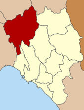
Amphoe Kaeng Hang Maeo (Thai: อำเภอ แก่งหางแมว) ist ein Landkreis (Amphoe - Verwaltungs-Distrikt) im Nordwesten der Provinz Chanthaburi. Die Provinz Chanthaburi liegt in der Ostregion von Zentralthailand.
Inhaltsverzeichnis
Geographie
Die benachbarten Amphoe sind im Uhrzeigersinn von Osten aus die Amphoe Soi Dao, Khao Khitchakut, Tha Mai und Na Yai Am der Provinz Chanthaburi, Amphoe Klaeng und Amphoe Khao Chamao der Provinz Rayong, Amphoe Bo Thong der Provinz Chonburi, Amphoe Tha Takiap der Provinz Chachoengsao und Amphoe Wang Sombun der Provinz Sa Kaeo.
Geschichte
Kaeng Hang Maeo wurde am 1. April 1990 zunächst als Unterbezirk (King Amphoe) eingerichtet, indem fünf Tambon vom Amphoe Tha Mai abgetrennt wurden. [1] Am 8. September 1992 bekam Kaeng Hang Maeo den vollen Amphoe-Status. [2]
Verwaltung
Ko Chan ist in fünf Kommunen (Tambon) eingeteilt, die sich weiter in 62 Dörfer (Muban) unterteilen. Es gibt keine Gebiete mit Stadtstatus (Thesaban) im Bezirk, aber es gibt fünf Tambon-Verwaltungs-Organisationen („Tambon Administrative Organizations“ - TAO, Thai: องค์การบริหารส่วนตำบล).
No. Name Thai Muban Einw. 1. Kaeng Hang Maeo แก่งหางแมว 21 8,395 2. Khun Song ขุนซ่อง 17 10,671 3. Sam Phinong สามพี่น้อง 9 5,345 4. Phawa พวา 12 9,086 5. Khao Wongkot เขาวงกต 3 2,956 Einzelnachweise
- ↑ ประกาศกระทรวงมหาดไทย เรื่อง แบ่งเขตท้องที่อำเภอท่าใหม่ จังหวัดจันทบุรี ตั้งเป็นกิ่งอำเภอแกงหางแมว Royal Gazette, Bd. 107, Ausg. 25 ง vom 13. February 1990, S. 1348 (in Thai)
- ↑ พระราชกฤษฎีกาตั้งอำเภอด่านมะขามเตี้ย อำเภอแก่งหางแมว อำเภอภักดีชุมพล อำเภอเวียงแก่น อำเภอแม่วาง อำเภอถ้ำพรรณรา อำเภอบ่อเกลือ อำเภอโนนสุวรรณ อำเภอห้วยราช อำเภอแม่ลาน อำเภอบางแก้ว อำเภอป่าพะยอม อำเภอหนองม่วงไข่ อำเภอยางสีสุราช อำเภอจังหาร อำเภอบ้านธิ อำเภอภูสิงห์ อำเภอบางกล่ำ อำเภอวังม่วง และอำเภอนายูง พ.ศ. ๒๕๓๘ Royal Gazette, Bd. 112, Ausg. 32 ก vom 8. August 1995, S. 1-3 (in Thai)
Weblinks
 Amphoe von Chanthaburi
Chanthaburi | Khlung | Tha Mai | Pong Nam Ron | Makham | Laem Sing | Soi Dao | Kaeng Hang Maeo | Na Yai Am | Khao Khitchakut
13.008333333333101.905Koordinaten: 13° 0′ N, 101° 54′ O


Wikimedia Foundation.