Majevica

Majevica
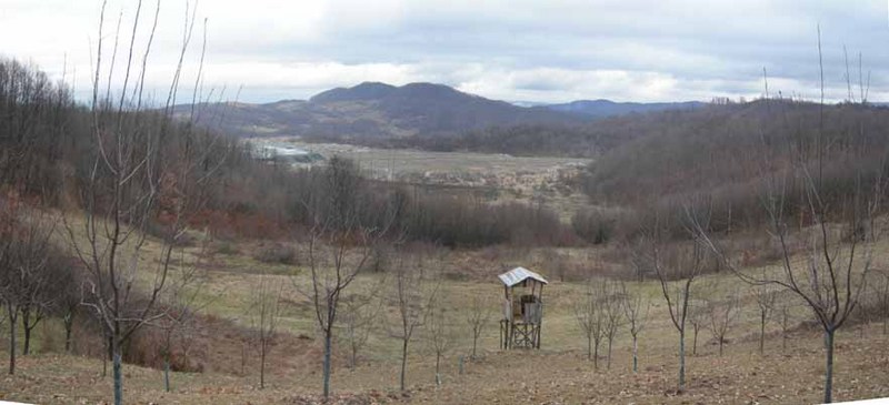
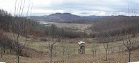
Blick auf den Tagebau Ugljevik und das Majevica-Gebirge

Majevica ist ein Mittelgebirge im Nordosten von Bosnien und Herzegowina, zwischen den Ebenen der Posavina und Semberija im Norden und der Spreča-Niederung (Sprečko polje) im Süden gelegen.

Höchster Punkt ist der Berg Stolice (916 m) bei Tuzla. Einige weitere Berge erreichen Höhen zwischen 800 und 900 m. Der größte Teil der Majevica ist bewaldet.

Zum Hauptkamm gehören von NW nach SO (etwa von Srebrenik Richtung Zvornik) Okresnica 815 m, Opakovica 690 m, Stublić 721 m, Tabakove strane 572 m, Kicelj 673 m, Gavranić 720 m, Greda 803 m, Međednik 842 m, Busija 845 m, Draganovac 779 m, Konjic 903 m, Stolice 916 m, Mala Jelica 879 m, Velika Jelica 878 m.[1]

Quellen

  1. http://opstinaugljevik.tripod.com/majevica.htm

Weblinks

44.51666666666718.883333333333916

Wikimedia Foundation.

Игры ⚽ Нужен реферат?

Schlagen Sie auch in anderen Wörterbüchern nach:

  • Majevica — Elevation 916 m (3,005 ft) Location Location …   Wikipedia

  • Majevica — Géographie Altitude 916 m, Stolice Massif Alpes dinariques Longueur …   Wikipédia en Français

  • Majevica — Sp Mãjevica Ap Majevica L kk. Bosnijoje ir Hercegovinoje …   Pasaulio vietovardžiai. Internetinė duomenų bazė

  • Ugljevik — Infobox Settlement settlement type = Municipality subdivision type = Country subdivision name =Bosnia and Herzegovinasubdivision type1 = Entity subdivision name1 = Republika Srpska subdivision type2 = subdivision name2 = timezone=CET utc… …   Wikipedia

  • 13th Waffen Mountain Division of the SS Handschar (1st Croatian) — The 13th Waffen Mountain Division of the SS Handschar (1st Bosnian) was one of the thirty eight divisions fielded as part of the Waffen SS during World War II. It was the largest of the SS divisions, with 21,065 men at its peakFact|date=October… …   Wikipedia

  • 1999 NATO bombing of Novi Sad — Razed building of TVNS in Mišeluk During the 1999 NATO bombing of Yugoslavia, the second largest Yugoslav city of Novi Sad was one of the cities that bore the brunt of the bombing. According to NATO press releases …   Wikipedia

  • Jugovićevo — (Југовићево) is a quarter of the city of Novi Sad in Serbia. BordersThe southern border of Jugovićevo is Bulevar Vojvode Stepe (Vojvoda Stepa Boulevard), the eastern border is a future new section of the Subotički bulevar (Subotica Boulevard),… …   Wikipedia

  • List of Bosnia and Herzegovina-related topics — This is a list of topics related to Bosnia and Herzegovina. Those interested in the subject can monitor changes to the pages by clicking on Related changes in the sidebar.Bosnia and Herzegovina* Bosnia and Herzegovina * Republika Srpska*… …   Wikipedia

  • Tuzla — Pour les articles homonymes, voir Tuzla (homonymie). 44° 32′ 17″ N 18° 40′ 34″ E …   Wikipédia en Français

  • Bijeljina — Infobox Settlement settlement type = subdivision type = Country subdivision name =Bosnia and Herzegovina subdivision type1= Entity subdivision name1 = Serbian Republic subdivision type2 = subdivision name2 = timezone=CET utc offset=+1 timezone… …   Wikipedia

Share the article and excerpts

Direct link
Do a right-click on the link above
and select “Copy Link”