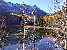
- Malheur National Forest
-
 Monument Rock Wilderness
Der am 13. Juni 1908 eröffnete Malheur National Forest ist ein Nationalforst im Osten des US-Bundesstaats Oregon im Gebirge Blue Mountains. Das ca. 6900 km² große Gebiet umfasst neben Wäldern auch Wüsten, Seen und Grünland. Es beginnt auf ca. 1200 Metern Höhe über dem Meer und reicht bis zur 2754 m hohen Spitze des Strawberry Mountains. Namensgeber ist der Fluss Malheur River.
Der Nationalforst wird vom United States Forest Service, einer Abteilung des US-amerikanischen Landwirtschaftsministeriums, betrieben. 1964 wurden das Gebiet um den Strawberry Mountain als Strawberry Mountain Wilderness und 1984 eine Region im Osten des Gebietes um den Bullrun Rock als Monument Rock Wilderness ausgewiesen. Beide Wilderness Areas sind von menschlichen Eingriffen unbeeinflusst.
Besonderheiten
In diesem Wald befindet sich ein Pilz (Armillaria ostoyae = Dunkler Hallimasch), der mit einem Alter von 2400 Jahren und einer Ausdehnung von ca. 900 ha bzw. 9 km² eines der ältesten und vermutlich das größte Lebewesen der Erde ist.
Weblinks
- Offizielle Seite des Malheur National Forest (Engl.)
- Info der Grant County Chamber of Commerce über den Malheur National Forest (Engl.)
- Informationen über den Pilz in Malheur National Forest von der Webseite der University of Wisconsin
 Commons: Malheur National Forest – Sammlung von Bildern, Videos und Audiodateien44.340179166667-118.84923933333Koordinaten: 44° 20′ 25″ N, 118° 50′ 57″ WKategorien:
- Geographie (Oregon)
- Waldgebiet in Nordamerika
- National Forest (Vereinigte Staaten)
Wikimedia Foundation.

