Marambio Island

Marambio Island
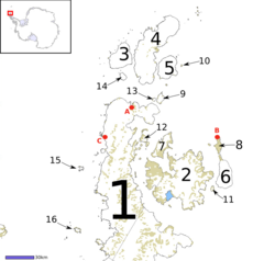
Seymour Island (Nr. 8) innerhalb der Inselkette an der Spitze der Antarktischen Halbinsel

Seymour Island liegt im Weddell-Meer, östlich der Nordspitze von Grahamland auf der Antarktischen Halbinsel. Nur wenige Kilometer nördlich von Snow Hill Island und nordöstlich von James Island liegt die Insel. Sie ist etwa 3 bis 8 km breit und 21 km lang. Im Jahre 1843 wurde sie durch den Britischen Seefahrer Sir James Clark Ross entdeckt.

Seymour Island

Die Insel wird manchmal auch nach dem dort ansässigen argentinischen Stützpunkt Marambio Island oder Seymour-Marambio Island genannt. Die Wissenschaftler dort beschäftigen sich u. a. mit Auroras und Meteorologie, Eigenschaften der Ionosphäre, Gletscherkunde, kosmischer Strahlung und Überwachung des Ozongehalts der Stratosphäre.

Neben großen Kolonien an Adéliepinguinen (Pygoscelis adeliae) brüten auf Seymour Island auch die Antipodenseeschwalbe (Gabelschwan, Seeschwalbe bzw. Antarktische Seeschwalbe) (Sterna vittata), die Dominikanermöwe (Larus dominicanus), die Antarktische Raubmöwe (C. maccormicki), die Subantarktis-Skua und die Buntfuß-Sturmschwalbe (Oceanites oceanicus).

Der norwegische Kapitän Carl Anton Larsen fand 1892 auf der Insel Fossilien. Die Insel ist seitdem, wie die benachbarte James Ross Insel, ein Traum für Paläontologen. Auf der Insel sind zahllose Fossilien entdeckt worden, darunter ausgestorbene Pflanzen, Wirbellose, Fische, Wale und Pinguinarten.

-64.233333333333-56.6166666666677Koordinaten: 64° 14′ S, 56° 37′ W


Wikimedia Foundation.

Игры ⚽ Поможем решить контрольную работу

Schlagen Sie auch in anderen Wörterbüchern nach:

  • Seymour-Marambio Island — Seymour Island (Nr. 8) innerhalb der Inselkette an der Spitze der Antarktischen Halbinsel Seymour Island liegt im Weddell Meer, östlich der Nordspitze von Grahamland auf der Antarktischen Halbinsel. Nur wenige Kilometer nördlich von Snow Hill… …   Deutsch Wikipedia

  • Marambio Base —   Antarctic base   …   Wikipedia

  • Marambio-Station — 64.233333333333 56.633333333333 Koordinaten: 64° 14′ 0″ S, 56° 38′ 0″ W …   Deutsch Wikipedia

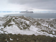
  • Seymour Island — A view from Seymour Island Geography Location Antarctica Coordinates 64°14′S, 56°37′W …   Wikipedia

  • Seymour Island — Gewässer Wedellmeer Geographische&# …   Deutsch Wikipedia

  • Seymour Island — ▪ island, Pacific Ocean       one of the smaller (area 1 sq mi [3 sq km]) of the Galapagos Islands, in the eastern Pacific Ocean directly north of Baltra Island, about 600 mi (965 km) west of mainland Ecuador. A large colony of land iguanas has… …   Universalium

  • Isla Marambio — Saltar a navegación, búsqueda Islote Bear Una vista desde la isla Marambio …   Wikipedia Español

  • Argentine Antarctica — ( es. Antártida Argentina) is a sector of Antarctica claimed by Argentina as part of its national territory. The Argentine Antarctic region, consisting of the Antarctic Peninsula and a triangular section extending to the South Pole, is delimited… …   Wikipedia

  • Аргентинская Антарктика — Аргентинская Антарктида …   Википедия

  • Chapel of Santisima Virgen de Lujan, Antarctica — The Chapel of Santisima Virgen de Lujan is a Roman Catholic chapel located at the Argentine base Marambio on Seymour Marambio Island in Antarctica[1]. The permanent steel structured chapel is used for Christian worship by the various Argentine… …   Wikipedia

Share the article and excerpts

Direct link
Do a right-click on the link above
and select “Copy Link”