Bötom — Karijoki 62° 18′ 28″ N 21° 42′ 24″ E / 62.3077, 21.7068 … Wikipédia en Français
botom — botme, botom obs. forms of bottom n … Useful english dictionary
DUB — Pour les articles homonymes, voir Dub (homonymie). Dub Origines stylistiques Reggae … Wikipédia en Français
Dub (musique) — Dub Pour les articles homonymes, voir Dub (homonymie). Dub Origines stylistiques Reggae … Wikipédia en Français
List of Finnish municipalities — This is a listing in alphabetical order of the current municipalities in Finland as of 2008. For population see List of Finnish municipalities by population. Notice that if the place has both a Finnish and a Swedish name, the majority language is … Wikipedia
List of Finnish municipalities by population — This is a list of the municipalities of Finland sorted by population as of 31st of December 2005:# Helsinki (Helsingfors) 560 905 {+0,3%} # Espoo (Esbo) 231 704 {+1,9%} # Tampere (Tammerfors) 204 337 {+0,7%} # Vantaa (Vanda) 187 281 {+1,0%} #… … Wikipedia
List of Finnish municipalities by area — This is a list of the municipalities of Finland sorted by area as of 1st of January 2006:# 17333.38 km²: Inari (Enare) # 12415.26 km²: Sodankylä # 8391.54 km²: Enontekiö (Enontekis) # 8263.09 km²: Kittilä # 8017.20 km²: Rovaniemi # 6496.64 km²:… … Wikipedia
Municipalities of Southern Ostrobothnia — This article is part of the Subdivisions of Finland series Regions Sub regions Municipalities list list by population list by area NUTS:FI ISO 3166 2:FI The 19 municipalities of Southern Ostrobothnia in Finland are divided on six sub regions … Wikipedia
LWS-6 Żubr — infobox Aircraft name =LWS 6 Żubr type =Medium bomber manufacturer =LWS caption = designer = first flight = March 1936 introduced = 1938 retired = 1940s status = primary user = Polish Air Force more users = produced = 1938 number built = 17 unit… … Wikipedia
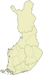
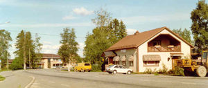
Karijoki — ( Bötom in Swedish) is a municipality of Finland.It is located in the province of Western Finland and is part of the Southern Ostrobothnia region. The municipality has a population of 1,686 (2003) and covers an area of 186.58 km² of which 0.53… … Wikipedia

 Karijoki

