Arizona State Route 347

Arizona State Route 347
Straßenschild der Arizona State Route 347
Karte
Karte der Arizona State Route 347
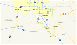
Basisdaten
Gesamtlänge:  28,5 mi/45,9 km
Anfangspunkt:  Arizona 84.svg AZ 84 nahe Stanfield
Endpunkt:  Straßenschild der I-10 I-10 nahe Sun Lakes
Countys:  Pinal County
Maricopa County

Die Arizona State Route 347 (kurz AZ 347) ist eine State Route im US-Bundesstaat Arizona, die in Nord-Süd-Richtung verläuft.

Die State Route beginnt an der Arizona State Route 84 westlich von Stanfield und endet nach 46 Kilometern nordwestlich von Sun Lakes an der Interstate 10.

Nach der Abzweigung von der AZ 84 verläuft die State Route 347 bis zur Stadt Maricopa in Richtung Norden. Innerhalb des Ortes zweigt die Arizona State Route 238 in westlicher Richtung ab und die AZ 347 führt anschließend in Richtung Nordosten. Sie endet nahe dem Gila River Memorial Airport an der Interstate 10

Siehe auch

Weblinks


Wikimedia Foundation.

Игры ⚽ Поможем сделать НИР

Schlagen Sie auch in anderen Wörterbüchern nach:

  • Arizona State Route 347 — Infobox road marker state=AZ highway name= name notes= type=state route=347 alternate name= maint= length mi=28.50 length round=2 length ref=cite web |url=http://tpd.az.gov/data/reports/2006SHSLog.pdf |title=2006 ADOT Highway Log |author=Arizona… …   Wikipedia

  • Arizona State Route 238 — Karte …   Deutsch Wikipedia

  • Arizona State Route 238 — Infobox road marker state=AZ highway name= name notes= type=state route=238 alternate name= maint= length mi=20.27 length round=2 length ref=cite web |url=http://tpd.az.gov/data/reports/2006SHSLog.pdf |title=2006 ADOT Highway Log |author=Arizona… …   Wikipedia

  • Arizona State Route 84 — Infobox road marker state=AZ highway name= name notes= type=state route=84 alternate name= maint= length mi=23.68 length round=2 length ref=cite web |url=http://tpd.az.gov/data/reports/2006SHSLog.pdf |title=2006 ADOT Highway Log |author=Arizona… …   Wikipedia

  • Arizona State Route 303 — Infobox road state=AZ type=SR route=303 alternate name= Estrella Freeway maint=ADOT length mi=21.84 length round=2 length ref=cite web |url=http://tpd.az.gov/data/reports/2006SHSLog.pdf |title=2006 ADOT Highway Log |author=Arizona Department of… …   Wikipedia

  • List of highways numbered 347 — The following highways are numbered 347: Canada Nova Scotia Route 347 United States Arizona State Route 347 Colorado State Highwa …   Wikipedia

  • Maricopa, Arizona — This is about the city. For the county, see Maricopa County City of Maricopa, Arizona   City   Residential developments dominate the landscape of Maricopa …   Wikipedia

  • State highways in New Jersey — Standard route signage in New Jersey Highway names Interstates: Interstate X (I X) …   Wikipedia

  • State highways in Colorado — The standard Colorado state highway sign. The top half is the flag of Colorado. Highway names Interstates: Interstate X (I X) US Routes: U.S. Highway X (US X) …   Wikipedia

  • Liste der Highways in Arizona — Dies ist eine Aufstellung von State Routes, U.S. Highways und Interstates im US Bundesstaat Arizona, nach Nummern. Inhaltsverzeichnis 1 State Routes 1.1 Gegenwärtige Strecken 1.2 Geplante Strecken 1.3 Außer Die …   Deutsch Wikipedia

Share the article and excerpts

Direct link
Do a right-click on the link above
and select “Copy Link”