- Rubiães
-
Rubiães Wappen Karte 
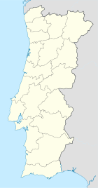

Basisdaten Region: Norte Unterregion: Minho-Lima Distrikt: Viana do Castelo Concelho: Paredes de Coura Koordinaten: 41° 54′ N, 8° 38′ W41.896347-8.625268Koordinaten: 41° 54′ N, 8° 38′ W Einwohner: 548 (Stand: 2001) Fläche: 9,2 km² Bevölkerungsdichte: 60 Einwohner pro km² Politik Webseite: www.jf-rubiaes.com Rubiães ist eine Gemeinde (Freguesia) im nordportugiesischen Kreis Paredes de Coura.
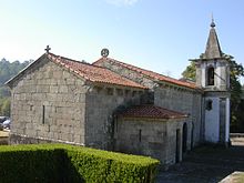 Kirche São Pedro von Rubiães - im 13. Jahrhundert erbaut
In ihr leben 548 Einwohner (Stand: 2001).[1]
Einzelnachweise
- ↑ Daten zu Rubiães (en). alea.pt. Abgerufen am 13. Mai 2011.
Weblinks
- Karte der Freguesia Rubiães beim Instituto Geográfico do Exército
 Freguesias im Concelho Paredes de Coura
Agualonga | Bico | Castanheira | Cossourado | Coura | Cristelo | Cunha | Ferreira | Formariz | Infesta | Insalde | Linhares | Mozelos | Padornelo | Parada | Paredes de Coura | Porreiras | Resende | Romarigães | Rubiães | Vascões
Wikimedia Foundation.
Schlagen Sie auch in anderen Wörterbüchern nach:
Rubiães — Infobox Parish pt official name = Rubiães image coat of arms = image location = Municipality = Paredes de Coura area total = 8.95 population total = 548 (2001) population density = 61.5 website = none footnotes =Rubiães is a Portuguese parish,… … Wikipedia
Ponte de Rubiães — 41.903942 8.626492 Koordinaten: 41° 54′ 14,2″ N, 8° 37′ 35,4″ W BWf1 … Deutsch Wikipedia
Quinta da Leiras- Rubiaes — (Paredes de Coura,Португалия) Категория отеля: Адрес: Lugar de S. Roque … Каталог отелей
Ponte de Rubiães — The Rubiães Roman bridge is a bridge by the Rio Coura located in the parish of Rubiães and is by the Way of St. James.The bridge is was constructed in the 2nd century [Structurae|id=s0020359|title=Roman Bridge] and is located next to the parish… … Wikipedia
Church of São Pedro de Rubiães — Coordinates: 41°53′46.88″N 8°37′32.39″W / 41.8963556°N 8.6256639°W / 41.8963556; 8.6256639 … Wikipedia
Monuments of Portugal — The Monuments of Portugal were constructed throughout the Portuguese territory, and date back to the period of pre historic settlement of occupation. Subsequently, the region that is today Portugal has been colonized by many civilizations, which… … Wikipedia
Paredes de Coura — Infobox Municipality pt official name = Paredes de Coura image coat of arms = PCR.png Region = Norte Subregion = Minho Lima District = Viana do Castelo Mayor name = António Júnior Mayor party = PS area total = 138.2 population total = 9,367… … Wikipedia
Römerstrasse — Miliarium Aureum, Ausgangspunkt aller Römerstraßen Römerstraße Via Appia in Rom … Deutsch Wikipedia
Römische Straßen — Miliarium Aureum, Ausgangspunkt aller Römerstraßen Römerstraße Via Appia in Rom … Deutsch Wikipedia
Straßen im Römischen Reich — Miliarium Aureum, Ausgangspunkt aller Römerstraßen Römerstraße Via Appia in Rom … Deutsch Wikipedia
Rubiães


18+
© Academic, 2000-2024
- Kontaktieren Sie uns: Unterstützung, Werbung
Wörterbücher Export, schritte mit PHP, Joomla, Drupal, WordPress, MODx.