- Anaktuvuk River
-
Anaktuvuk River
Anukturuk RiverGewässerkennzahl US: 1398236 Lage North Slope in Alaska (USA) Flusssystem Colville River Abfluss über Colville River → Arktischer Ozean Quelle Endicott Mountains
68° 0′ 0″ N, 150° 45′ 0″ W68-150.75Mündung Colville River 69.516666666667-151.539Koordinaten: 69° 31′ 0″ N, 151° 30′ 0″ W
69° 31′ 0″ N, 151° 30′ 0″ W69.516666666667-151.539Mündungshöhe 39 m[1] Länge 215 km[1] Rechte Nebenflüsse Kanayut River, Nanushuk River 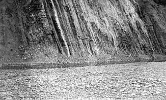
Felswand am Anaktuvuk River
(Aufnahme aus dem Jahr 1901)Der Anaktuvuk River (auch Anukturuk River[2]) ist ein 215 km (135 Meilen) langer Fluss in der North Slope im Norden des US-Bundesstaates Alaska.[1] In Inupiaq, der Sprache der Inupiat, bedeutet der Name des Flusses „Ort des Karibukots“, ein Hinweis darauf, dass hier große Karibuherden durchziehen.
Er entspringt im Norden der Brookskette, fließt vorwiegend in nördlicher Richtung und mündet in den Colville River.
Der Kanayut River und der Nanushuk River sind die einzigen bedeutenden Nebenflüsse des Anaktuvuk River.
Einzelnachweise
- ↑ a b c USGS - GNIS - Anaktuvuk River
- ↑ Orth, Donald J. Dictionary of Alaska Place Names. Washington, DC: GPO, 1967. This work is an alphabetical list of the geographic names generally including feature descriptions and often name origin information that are now applied and have been applied to places and features in Alaska. GNIS Library. p74
Weblinks
Kategorien:- Flusssystem Colville River
- Fluss in Alaska
- Fluss in Nordamerika
- North Slope Borough

Wikimedia Foundation.