Liptovská Mara

Liptovská Mara
Liptauer Stausee
Luftaufnahme des Stausees
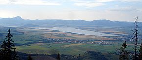
Größere Städte am Ufer: Liptovský Mikuláš
Geographische Lage 49° 5′ 33″ N, 19° 29′ 12″ O49.092519.4866666666677Koordinaten: 49° 5′ 33″ N, 19° 29′ 12″ O
Daten Bauwerk
Bauzeit: 1965–1975
Kraftwerksleistung: 200 MW
Daten Stausee
Wasseroberfläche bei Vollstau: 22 km²
Speicherraum: 360.000.000 m³

Der Liptauer Stausee (slowak. Liptovská Mara) ein Stausee in der Slowakei am Fluss Waag nahe dem Ort Liptovský Mikuláš in der Liptau.

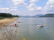
Liptauer Stausee bei Dechtáre

Der Stausee wurde zwischen 1965 und 1975 errichtet. Die Wasserfläche beträgt 22 km², seine maximale Tiefe beträgt 45 Meter. Mit einem Stauvolumen von 360 Millionen m³ Wasser ist er der größte Wasserspeicher (nach Volumen) der Slowakei. Für den Bau wurden mehrere Dörfer (unter anderem Liptovská Sielnica, Paludza, Parížovce, Nežitovce, Zádiel, Dechtáre, Sokolče, Čemice, Vŕbie, Ráztoky und das namensgebende Liptovská Mara), völlig aufgegeben.

Hauptfunktion des Stausees ist der Hochwasserschutz, er dient aber auch zur Elektroenergieerzeugung, welche an 4 Turbinen eine Leistung von 200 MW erzeugen. Die Nutzung für Tourismus und Naherholung hält sich derzeit relativ in Grenzen. Es gibt das Erholungszentrum bei Liptovský Trnovec mit dem nahen Aquapark Tatralandia.

Die Halbinsel Ratkovie und die sie umgebende Wasserfläche ist Schutzgebiet. Am Westufer bei der Gemeinde Bobrovník befindet sich die archäologische Fundstätte Havránok.

Weblinks


Wikimedia Foundation.

Игры ⚽ Поможем написать курсовую

Schlagen Sie auch in anderen Wörterbüchern nach:

  • Liptovská Mara — is a reservoir in northern Slovakia, on the Váh river near Liptovský Mikuláš, in the Liptov region. The dam is named after one of the inundated villages.It was built in 1965 1975. The area of the reservoir is 22 km², max. depth is 45 m and the… …   Wikipedia

  • Ubytovanie na lodi - Liptovská Mara — (Липтовска Сиельница,Словакия) Категория отеля: Адрес: Okoličné …   Каталог отелей

  • Liptauer Stausee — Luftaufnahme des Stausees …   Deutsch Wikipedia

  • Havránok — is an important archaeological site in northern Slovakia. It is located on a hill above the Liptovská Mara water reservoir around 2 km from the village of Bobrovník, about halfway between Ružomberok and Liptovský Mikuláš in the Liptov region. The …   Wikipedia

  • Bahnstrecke Košice-Žilina — Košice–Poprad Tatry–Žilina Bahnhof Ružomberok …   Deutsch Wikipedia

  • Bahnstrecke Žilina-Košice — Košice–Poprad Tatry–Žilina Bahnhof Ružomberok …   Deutsch Wikipedia

  • Bahnstrecke Žilina–Košice — Košice–Poprad Tatry–Žilina Bahnhof Ružomberok …   Deutsch Wikipedia

  • Komitat Liptau — (Liptó) (1910) Verwaltungssitz: Liptószentmiklós Fläche: 2.246 km² …   Deutsch Wikipedia

  • Liptó (county) — Infobox Former Subdivision native name = Liptó Vármegye conventional long name = Liptó County common name = Liptó subdivision = County nation = the Kingdom of Hungary p1 = s1 = Czechoslovakia flag s1 = Flag of Czechoslovakia.svg year start = 15th …   Wikipedia

  • Liptov — is an informal designation of region in Slovakiam part of the former Kingdom of Hungary, Liptó county. NOTOC GeographyThe territory largely corresponds to the Ružomberok District and Liptovský Mikuláš District in northern Slovakia. Three villages …   Wikipedia

Share the article and excerpts

Direct link
Do a right-click on the link above
and select “Copy Link”