- Norwegian Continental Shelf
-
 Förderaktivität auf dem norwegischen Kontinentalschelf in der Nordsee (rotbraun), im Nordmeer (hellbraun) und in der Barentssee (grün)
 Der Kontinentalschelf ist der Teil des Kontinentrandes, der bei geringer Tiefe unterhalb der Meeresoberfläche liegt
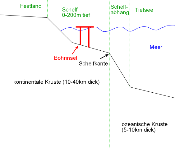
Der (oder das) Norwegische Kontinentalschelf (Norwegian Continental Shelf) ist der Teil des europäischen Kontinentalrandes, der als Festlandsockel entlang der norwegischen Küste verläuft. Seine Ausdehnung entspricht ungefähr einem Drittel der Ausdehnung des gesamten europäischen Kontinentalschelfs; er erstreckt sich über ein Gebiet, das etwa vier mal so groß ist wie das norwegische Festland selbst.
Inhaltsverzeichnis
Geographische Besonderheiten
Ein Teil der Nordsee liegt auf dem norwegischen Kontinentalschelf. Diese verbindet das norwegische Kontinentalschelf bei geringer Tiefe unter 200 Metern fast übergangslos mit dem britischen. Lediglich an einer Stelle, der norwegischen Rinne, erreicht sie eine Tiefe von bis zu 700 Metern.
Wirtschaftliche und politische Bedeutung
Im Schelf wird nach Erdöl und Erdgas gesucht. Der Abbau dieser Rohstoffe erfolgt hauptsächlich durch die staatliche Mineralölgesellschaft Statoil und die ebenfalls norwegische Gesellschaft Norsk Hydro und macht Norwegen mit durchschnittlich drei Millionen Barrel pro Tag nach Saudi-Arabien und Russland zum drittgrößten Erdölexporteur der Welt. Obwohl die Ölreserven im norwegischen Kontinentalschelf nur einen verhältnismäßig geringen Teil der weltweiten Ölreserven ausmachen (wenige Prozent), stellen sie dennoch etwa die Hälfte der Ölreserven Europas. Der größte Teil der Ölbohraktivität im Bereich des Schelfs findet in der Nordsee und im südlichen Teil des europäischen Nordmeers statt. Gegen Ende des 20. Jahrhunderts begann jedoch ein Ölboom Nordnorwegen zu ergreifen, nachdem von Statoil die weltweit erste Offshore-Operation in der Arktis im Snøhvit-Erdgasfeld (norwegisch „Schneeweiß“) begonnen wurde. Auf der Insel Melkøya in der Nähe von Hammerfest entsteht die größte Erdgasverflüssigungsanlage Norwegens, eines der bisher teuersten Projekte in Nordnorwegen.
Literatur
- Roald Sætre (Hrsg.): The Norwegian Coastal Current - Oceanography and Climate. Tapir Academic Press, Trondheim 2007. ISBN 978-82-519-2184-8
Weblinks

Wikimedia Foundation.