- Olutanga
-
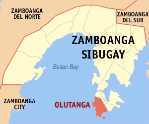
Municipality of Olutanga Lage von Olutanga in der Provinz Zamboanga Sibugay 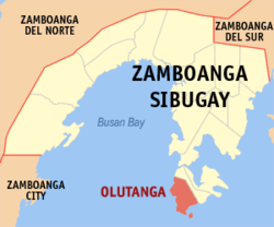
Basisdaten Bezirk: Zamboanga Peninsula Provinz: Zamboanga Sibugay Barangays: 19 Distrikt: 3. Distrikt von Zamboanga Sibugay PSGC: 098310000 Einkommensklasse: 4. Einkommensklasse Haushalte: 4037 Zensus 1. Mai 2000Einwohnerzahl: 27.521 Zensus 1. August 2007Koordinaten: 7° 20′ N, 122° 50′ O7.3333333333333122.83333333333Koordinaten: 7° 20′ N, 122° 50′ O Geographische Lage auf den Philippinen 

Olutanga Olutanga ist eine philippinische Stadtgemeinde in der Provinz Zamboanga Sibugay. Nach dem Zensus vom 1. Mai 2000 hat sie 22.624 Einwohner in 4037 Haushalten.
Baranggays
Olutanga ist politisch in 19 Baranggays unterteilt.
- Bateria
- Calais (Kalines)
- Esperanza
- Fama
- Galas
- Gandaan
- Kahayagan
- Looc Sapi
- Matim
- Noque
- Pulo Laum
- Pulo Mabao
- San Isidro
- San Jose
- Santa Maria
- Solar (Pob.)
- Tambanan
- Villacorte
- Villagonzalo
Schlagen Sie auch in anderen Wörterbüchern nach:
Olutanga — Original name in latin Olutanga Name in other language Calida, Olutanga, Suba Nipa State code PH Continent/City Asia/Manila longitude 7.31056 latitude 122.84639 altitude 19 Population 7133 Date 2011 07 31 … Cities with a population over 1000 database
Olutanga, Zamboanga Sibugay — Olutanga Municipality Map of Zamboanga Sibugay showing the location of Olutanga … Wikipedia
List of hospitals in the Philippines — This is a partial list of hospitals in the Philippines.LuzonILOCOS NORTE*Mariano Marcos Memorial Hospital Batac CityBaguio City*Baguio General Hospital *Saint Louis University Hospital of the Secret Heart *BCU Sto. Nino Jesus Hospital foundation… … Wikipedia
PH-ZSI — Lage von Zamboanga Sibugay Zamboanga Sibugay nimmt den südöstlichen Bereich der Halbinsel Zamboanga auf der Insel Mindanao ein und ist eine Provinz der Philippinen. Die Hauptstadt der Provinz ist die Gemeinde Ipil. Zamboanga Sibugay gehört zum… … Deutsch Wikipedia
Diplahan, Zamboanga Sibugay — Diplahan Municipality Map of Zamboanga Sibugay showing the location of Diplahan … Wikipedia
Malangas, Zamboanga Sibugay — Municipality of Malangas … Wikipedia
Naga, Zamboanga Sibugay — Naga Municipality Map of Zamboanga Sibugay showing the location of Naga … Wikipedia
List of cities and municipalities in the Philippines — This is a list of cities and municipalities in the Philippines arranged by province and in alphabetical order. As of 2006, there are 118 cities and 1509 municipalities.As of September 4, 2007, there are 136 cities, 1,495 municipalities, 81… … Wikipedia
Divine Word Missionaries — The Society of the Divine Word (Latin: Societas Verbi Divini, abbreviated SVD), popularly called the Divine Word Missionaries, and sometimes the Steyler Missionaries, is a missionary religious congregation in the Latin Church, one of the 23 sui… … Wikipedia
List of ZIP Codes in the Philippines — In the Philippines, the Philippine ZIP code is used by the Philippine Postal Corporation (Philpost) to simplify the distribution of mail. While in function it is similar to the ZIP code used in the United States, its form and its usage is quite… … Wikipedia
Olutanga

18+
© Academic, 2000-2026
- Kontaktieren Sie uns: Unterstützung, Werbung
Wörterbücher Export, schritte mit PHP, Joomla, Drupal, WordPress, MODx.