Paliokastro

Paliokastro
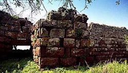
Paliokastro von Methana
Paliokastro von Nisyros

Paliokastro (griechisch Παλιόκαστρο (n. sg.)) ist die griechische Bezeichnung für alte Burg. Solche Orte findet man in Griechenland recht häufig. Meist bezeichnen diese Ortsnamen Burgen und sogar Akropolen aus der antiken oder vorgeschichtlichen Zeit. Beispiele findet man beispielsweise auf Methana oder Nisyros.

  • Paliokastro ist auch der Name eines Ortes auf Kreta, fünf Kilometer westlich von Iraklio. Hier befinden sich Ruinen einer venezianischen Festung und es gibt einen Strand mit einigen Tavernen.
  • Palekastro ist ein bäuerliches Dorf im Osten Kretas in unmittelbarer Nähe des berühmten Palmenstrandes von Vai.
  • Außerdem ist Paliokastro auch der moderne Name für die mykenische Burg Gla in Böotien, Griechenland.
  • Die Bezeichnung findet man auch in Süditalien, wo die antike großgriechische Stadt Pyxous in byzantinischer Zeit Palaiokastro (heute Policastro Bussentino, in der Provinz Salerno) umbenannt wurde.

Wikimedia Foundation.

Игры ⚽ Нужно решить контрольную?

Schlagen Sie auch in anderen Wörterbüchern nach:

  • Paliokastro Guesthouse — (Като Трикала Коринтия,Греция) Категория отеля: Адрес: Kato Trikala Korinthias …   Каталог отелей

  • Paliokastro — Paleokastro ( Παλαιοκαστρο ) is a municipality in the Trikala Prefecture, Greece …   Wikipedia

  • Akropolis Paliokastro — 37.58666666666723.349444444444 Koordinaten: 37° 35′ 12″ N, 23° 20′ 58″ O …   Deutsch Wikipedia

  • Aptera (Grèce) — 35° 27′ 46″ N 24° 08′ 31″ E / 35.4629, 24.142 …   Wikipédia en Français

  • Akropolislage — Die Akropolis, (altgriechisch: ἡ ἀκρόπολις ʰē akrópolis, „Oberstadt“, aus ἄκρος ákros, „höchster“, „äußerster“, und ἡ πόλις (altgr. Gen. εως) ʰē pólis, „Stadtstaat“, „Stadt“) ist die auf dem höchstgelegenen Teil einer griechischen Stadt gelegene… …   Deutsch Wikipedia

  • Oichalia, Trikala — For other uses, see Oichalia (disambiguation). Oichalia Οιχαλία Location …   Wikipedia

  • Greek National Road 30 — InformationThe highway starts in downtown Volos with the junction of the GR 36 and GR 36A linking to the Pelion peninsula, it partly runs within the port of Volos and its harbour. For about 8 km it forms a joint with the GR 6. The highway forms a …   Wikipedia

  • Angariones — or Agaryones (Greek: Αγγαριώνες), accented forms: Angariónes and Agaryónes is a village in the Greek island of Limnos, and is the seat of Nea Koutali. Its 2001 population was 138 for the village and the municipal district.Nearest… …   Wikipedia

  • GR-EO20 — Datei:Flag of Greece.svg Nationalstraße 20 (Ethiniki Odos 20) Länge: ca. 150 km   …   Deutsch Wikipedia

  • Methana — Stadtgemeinde Methana (1934–2010) Δήμος Μεθάνων (Μέθανα) …   Deutsch Wikipedia

Share the article and excerpts

Direct link
Do a right-click on the link above
and select “Copy Link”