- Panitan
-
Municipality of Panitan Lage von Panitan in der Provinz Capiz 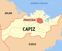
Basisdaten Bezirk: Western Visayas Provinz: Capiz Barangays: 26 Distrikt: 1. Distrikt von Capiz PSGC: 061910000 Einkommensklasse: 4. Einkommensklasse Haushalte: 7073 Zensus 1. Mai 2000Einwohnerzahl: 38.666 Zensus 1. August 2007Koordinaten: 11° 28′ N, 122° 46′ O11.469122.769Koordinaten: 11° 28′ N, 122° 46′ O Postleitzahl: 5815 Bürgermeister: Katherine D. Belo Offizielle Webpräsenz: Panitan Geographische Lage auf den Philippinen 

Panitan Panitan ist eine philippinische Stadtgemeinde in der Provinz Capiz. Nach dem Zensus vom 1. Mai 2000 hat sie 37.458 Einwohner in 7.073 Haushalten.
Baranggays
Panitan ist politisch in 26 Baranggays unterteilt.
- Agbabadiang
- Agkilo
- Agloway
- Ambilay
- Bahit
- Balatucan
- Banga-an
- Cabugao
- Cabangahan
- Cadio
- Cala-an
- Capagao
- Cogon
- Conciencia
- Ensenagan
- Intampilan
- Pasugue
- Poblacion Ilawod
- Poblacion Ilaya
- Quios
- Salocon
- Tabuc Norte
- Tabuc Sur
- Timpas
- Tincupon
- Tinigban
Städte und Stadtgemeinden in der Provinz CapizStädte: Roxas City
Stadtgemeinden: Cuartero | Dao | Dumalag | Dumarao | Ivisan | Jamindan | Ma-ayon | Mambusao | Panay | Panitan | Pilar | Pontevedra | President Roxas | Sapi-an | Sigma | Tapaz
Wikimedia Foundation.
Schlagen Sie auch in anderen Wörterbüchern nach:
Panitan — Original name in latin Panitan Name in other language Panatan, Paniban, Panitan State code PH Continent/City Asia/Manila longitude 11.466 latitude 122.7725 altitude 14 Population 5156 Date 2011 07 31 … Cities with a population over 1000 database
Panitan, Capiz — Panitan is a 4th class municipality in the province of Capiz, Philippines. According to the 2000 census, it has a population of 37,458 people in 7,073 households.BarangaysPanitan is politically subdivided into 26 barangays. * Agbabadiang * Agkilo … Wikipedia
Magallanes, Cavite — Municipality of Magallanes, Cavite Bayan ng Magallanes, Kabite Municipality … Wikipedia
PH-CAP — Karte der Philippinen mit der Lage von Capiz Karte der Insel Panay/Philippinen Capiz ist eine Provinz auf der Insel Panay, die zu dem Inselstaat der Philippinen gehört … Deutsch Wikipedia
Roxas City — Infobox Philippine city infoboxtitle = Roxas City | sealfile = Ph seal capiz roxas.png locatormapfile = Ph locator capiz roxas.png caption = Map of Capiz showing the location of Roxas City region = Western Visayas (Region VI) province = Capiz… … Wikipedia
Cuartero, Capiz — Map of Capiz showing the location of Cuartero Cuartero is a 4th class municipality in the province of Capiz, Philippines. According to the 2000 census, it has a population of 24,286 people in 4,681 households. Barangays Cuartero is politically… … Wikipedia
Dao, Capiz — Map of Capiz showing the location of Dao Dao is a 4th class municipality in the province of Capiz, Philippines. According to the 2000 census, it has a population of 30,623 people in 5,921 households. Contents 1 … Wikipedia
Dumalag, Capiz — Map of Capiz showing the location of Dumalag Dumalag is a 4th class municipality in the province of Capiz, Philippines. According to the 2000 census, it has a population of 25,920 people in 5,375 households. Barangays Dumalag is politically… … Wikipedia
Dumarao, Capiz — Map of Capiz showing the location of Dumarao Dumarao is a 3rd class municipality in the province of Capiz, Philippines. According to the 2000 census, it has a population of 40,303 people in 7,993 households. It was originally founded in 1580 and… … Wikipedia
Mambusao, Capiz — Map of Capiz showing the location of Mambusao Mambusao is a 1st class municipality in the province of Capiz, Philippines. According to the 2000 census, it has a population of 36,793 people in 7,421 households. Mambusao is the home of the… … Wikipedia
Panitan


18+
© Academic, 2000-2026
- Kontaktieren Sie uns: Unterstützung, Werbung
Wörterbücher Export, schritte mit PHP, Joomla, Drupal, WordPress, MODx.