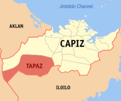
- Tapaz
-
Municipality of Tapaz Lage von Tapaz in der Provinz Capiz 
Basisdaten Bezirk: Western Visayas Provinz: Capiz Barangays: 58 Distrikt: 2. Distrikt von Capiz PSGC: 061917000 Einkommensklasse: 2. Einkommensklasse Haushalte: 8739 Zensus 1. Mai 2000Einwohnerzahl: 47.059 Zensus 1. August 2007Koordinaten: 11° 16′ N, 122° 32′ O11.266666666667122.53333333333Koordinaten: 11° 16′ N, 122° 32′ O Postleitzahl: 5814 Bürgermeister: Rosemarie F. Gradose Offizielle Webpräsenz: www.tapaz.gov.ph Geographische Lage auf den Philippinen Tapaz ist eine philippinische Stadtgemeinde in der Provinz Capiz. Nach dem Zensus vom 1. Mai 2000 hat sie 44.085 Einwohner in 8.739 Haushalten.
Baranggays
Tapaz ist politisch in 58 Baranggays unterteilt.
- Abangay
- Acuña
- Agcococ
- Aglinab
- Aglupacan
- Agpalali
- Apero
- Artuz
- Bag-Ong Barrio
- Bato-bato
- Buri
- Camburanan
- Candelaria
- Carida
- Cristina
- Da-an Banwa
- Da-an Norte
- Da-an Sur
- Garcia
- Gebio-an
- Hilwan
- Initan
- Katipunan
- Lagdungan
- Lahug
- Libertad
- Mabini
- Maliao
- Malitbog
- Minan
- Nayawan
- Poblacion
- Rizal Norte
- Rizal Sur
- Roosevelt
- Roxas
- Salong
- San Antonio
- San Francisco
- San Jose
- San Julian
- San Miguel Ilawod
- San Miguel Ilaya
- San Nicolas
- San Pedro
- San Roque
- San Vicente
- Santa Ana
- Santa Petronila
- Senonod
- Siya
- Switch
- Tabon
- Tacayan
- Taft
- Taganghin
- Taslan
- Wright
Städte und Stadtgemeinden in der Provinz CapizStädte: Roxas City
Stadtgemeinden: Cuartero | Dao | Dumalag | Dumarao | Ivisan | Jamindan | Ma-ayon | Mambusao | Panay | Panitan | Pilar | Pontevedra | President Roxas | Sapi-an | Sigma | Tapaz
Wikimedia Foundation.
Schlagen Sie auch in anderen Wörterbüchern nach:
Tapaz, Capiz — Tapaz is a 3rd class municipality in the province of Capiz, Philippines. According to the 2000 census, it has a population of 44,085 people in 8,739 households.BarangaysTapaz is politically subdivided into 58 barangays. * Abangay * Acuña *… … Wikipedia
PH-CAP — Karte der Philippinen mit der Lage von Capiz Karte der Insel Panay/Philippinen Capiz ist eine Provinz auf der Insel Panay, die zu dem Inselstaat der Philippinen gehört … Deutsch Wikipedia
Quípama — Saltar a navegación, búsqueda 5°31′15″N 74°11′00″O / 5.52083, 74.183333 … Wikipedia Español
Capiz — Karte der Philippinen mit der Lage von Capiz Karte der Insel Panay/Philippinen … Deutsch Wikipedia
List of hospitals in the Philippines — This is a partial list of hospitals in the Philippines.LuzonILOCOS NORTE*Mariano Marcos Memorial Hospital Batac CityBaguio City*Baguio General Hospital *Saint Louis University Hospital of the Secret Heart *BCU Sto. Nino Jesus Hospital foundation… … Wikipedia
Santa Josefa, Agusan del Sur — Infobox Philippine municipality infoboxtitle = Municipality of Santa Josefa sealfile = locatormapfile = Ph locator agusan del sur santa josefa.png caption = Map of Agusan del Sur showing the location of Santa Josefa. region = Caraga (Region XIII) … Wikipedia
Cuartero, Capiz — Map of Capiz showing the location of Cuartero Cuartero is a 4th class municipality in the province of Capiz, Philippines. According to the 2000 census, it has a population of 24,286 people in 4,681 households. Barangays Cuartero is politically… … Wikipedia
Dao, Capiz — Map of Capiz showing the location of Dao Dao is a 4th class municipality in the province of Capiz, Philippines. According to the 2000 census, it has a population of 30,623 people in 5,921 households. Contents 1 … Wikipedia
Dumalag, Capiz — Map of Capiz showing the location of Dumalag Dumalag is a 4th class municipality in the province of Capiz, Philippines. According to the 2000 census, it has a population of 25,920 people in 5,375 households. Barangays Dumalag is politically… … Wikipedia
Dumarao, Capiz — Map of Capiz showing the location of Dumarao Dumarao is a 3rd class municipality in the province of Capiz, Philippines. According to the 2000 census, it has a population of 40,303 people in 7,993 households. It was originally founded in 1580 and… … Wikipedia

