Pelly Mountains

Pelly Mountains

p1f1

Pelly Mountains
Höchster Gipfel Fox Mountain (2.404 m)
Lage Yukon (Kanada)
Pelly Mountains (Kanada)
Pelly Mountains
Koordinaten 61° 55′ N, 133° 22′ W61.9225-133.367777777782404Koordinaten: 61° 55′ N, 133° 22′ W
Fläche 44.014 km²

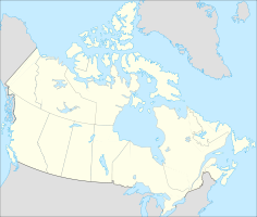
Die Pelly Mountains sind ein Gebirgszug in den Yukon Intermountain Ranges nordöstlich des Yukon. Die Westflanke erstreckt sich von Carcross im Süden über Whitehorse bis Carmacks im Nordwesten. Die Pelly Mountains liegen im kanadischen Territorium Yukon. Mit einer Ausdehnung von 288 km in nordsüdlicher und 439 km in ostwestlicher Richtung bedecken sie eine Fläche von 44.014 km². Der höchste Berg ist der Fox Mountain mit 2404 m.

Der Pelly River bildet die nördliche Grenze des Gebirges. Die Quellen von Nisutlin und Liard River liegen in den Pelly Mountains. Nordöstlich schließen die Selwyn Mountains und südöstlich die Cassiar Mountains an.

Berge der Pelly Mountains

  • Fox Mountain (2.404 m)
  • Truitt Peak (2.088 m)
  • Snowcap Mountain (1.782 m)

Weblinks


Wikimedia Foundation.

Игры ⚽ Поможем написать реферат

Schlagen Sie auch in anderen Wörterbüchern nach:

  • Pelly Mountains — Geobox | Range name=Pelly Mountains other name= image size= image caption= country=Canada region=Yukon parent=Yukon Ranges geology= geology1= geology2= orogeny= highest= highest elevation= highest lat d=|highest lat m=|highest lat s=|highest lat… …   Wikipedia

  • Pelly Mountains — Sp Pèlio kalna Ap Pelly Mountains L Kanadoje (Jukono teritorija) …   Pasaulio vietovardžiai. Internetinė duomenų bazė

  • Pelly — ist der Familienname folgender Personen: Claude Pelly (1902–1972), britischer Offizier der Royal Air Force Laurent Pelly (* 1962), französischer Opern und Theaterregisseur Lewis Pelly (1825–1892), britischer Politiker Thomas Pelly (1902–1973), US …   Deutsch Wikipedia

  • Pelly River — Pelly River, Fluß in dem kanad. Yukon Territorium, vom Felsengebirge, fließt durch die Pelly Seen, dem Nordostabhang der Pelly Mountains (2100 m) entlang und vereinigt sich, 800 km lang, bei Fort Selkirk mit dem Lewis zum Yukon (s. d.) …   Meyers Großes Konversations-Lexikon

  • Pelly River —    Rises in the Pelly Mountains about lat. 62°, and flows into the Yukon after a course of 330 miles. Discovered and explored by Robert Campbell between the years 1840 1848. Campbell reached the upper waters of the Pelly, by way of the Liard, in… …   The makers of Canada

  • Pelly River — Einzugsgebiet des Pelly River DatenVorlage:Infobox Fluss/GKZ fehlt …   Deutsch Wikipedia

  • Pelly River — The Pelly River is a river in Canada, and is a headstream of the Yukon River. The river originates west of the Mackenzie Mountains flows 530 km long through the south central Yukon. The Pelly has two main tributaries, the Ross and Macmillan… …   Wikipedia

  • Pelly River — ▪ stream, Yukon Territory, Canada       stream in central Yukon Territory, Canada, one of the main headstreams of the Yukon River. It was named in 1840 by Robert Campbell for Sir John Henry Pelly, governor of the Hudson s Bay Company. Rising in… …   Universalium

  • List of mountains of Canada — Main article: Mountain peaks of Canada The vast majority of mountains in Canada lie in the western provinces of British Columbia and Alberta and the Yukon Territory. Mountains can be found all over British Columbia while those in Alberta are… …   Wikipedia

  • Rocky Mountains — (spr. róckĭ mauntĭns, Felsengebirge; s. die »Fluß und Gebirgskarte von Nordamerika« [Bd. 14] und Karte »Britisch Nordamerika« bei Artikel »Kanada«), die Gesamtheit der binnenländischen Gebirgsketten und Hochflächen, welche die Westhälfte des… …   Meyers Großes Konversations-Lexikon

Share the article and excerpts

Direct link
Do a right-click on the link above
and select “Copy Link”