- Liard River
-
Liard River 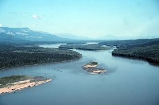
Liard River
Daten Lage Yukon, British Columbia, Nordwest-Territorien (Kanada) Flusssystem Mackenzie River Abfluss über Mackenzie River → Nordpolarmeer Quelle in den Pelly Mountains Mündung bei Fort Simpson in den Mackenzie River 61.847078767026-121.29180908203Koordinaten: 61° 50′ 49″ N, 121° 17′ 31″ W
61° 50′ 49″ N, 121° 17′ 31″ W61.847078767026-121.29180908203Länge 1.115 km[1] Einzugsgebiet 277.100 km²[1] Rechte Nebenflüsse Dease River, Kechika River, Fort Nelson River, Petitot River, Muskeg River Linke Nebenflüsse Frances River, Hyland River, South Nahanni River Der Liard River ist ein 1.115 Kilometer langer linker Nebenfluss des Mackenzie River im Yukon-Territorium, den Nordwest-Territorien und in der Provinz British Columbia. Der Fluss entspringt in den Pelly Mountains im südöstlichen Yukon und mündet bei Fort Simpson, Nordwest-Territorien in den Mackenzie River. Er entwässert ein Gebiet von etwa 277.100 km² und fließt durch das Liard River Valley.
Inhaltsverzeichnis
Geschichte
Der Name des Flusses wird von der französischen Bezeichnung liard für die Pappeln (Populus deltoides) abgeleitet, die am Ufer des Flusses wachsen.
Nebenflüsse
- South Nahanni River
- Muskeg River
- Petitot River
- Kotaneelee River
- Fort Nelson River
- Kechika River
- Hyland River
- Dease River
- Frances River
Weblinks
 Commons: Liard River – Sammlung von Bildern, Videos und Audiodateien
Einzelnachweise
Kategorien:- Flusssystem Mackenzie River
- Fluss in Yukon
- Fluss in British Columbia
- Fluss in den Nordwest-Territorien
- Fluss in Nordamerika

Wikimedia Foundation.