Pigkawayan

Pigkawayan
Municipality of Pigkawayan
Lage von Pigkawayan in der Provinz Cotabato
Karte
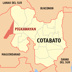
Basisdaten
Bezirk: SOCCSKSARGEN
Provinz: Cotabato
Barangays: 40
Distrikt: 1. Distrikt von Cotabato
PSGC: 124711000
Einkommensklasse: 2. Einkommensklasse
Haushalte: 10.112
Zensus 1. Mai 2000
Einwohnerzahl: 59.395
Zensus 1. August 2007
Koordinaten: 7° 17′ N, 124° 26′ O7.2833333333333124.43333333333Koordinaten: 7° 17′ N, 124° 26′ O
Postleitzahl: 9412
Geographische Lage auf den Philippinen
Pigkawayan (Philippinen)
Pigkawayan
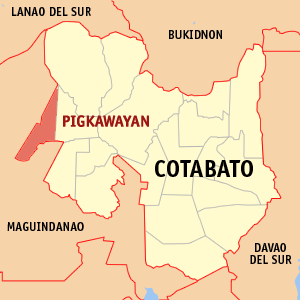
Pigkawayan

Pigkawayan ist eine philippinische Stadtgemeinde in der Provinz Cotabato. Nach dem Zensus vom 1. Mai 2000 hat sie 51.008 Einwohner in 10.112 Haushalten.

Baranggays

Pigkawayan ist politisch in 40 Baranggays unterteilt.

  • Anick (Upper Balogo)
  • Upper Baguer (Baguer)
  • Balacayon
  • Balogo
  • Banucagon
  • Bulucaon
  • Buluan
  • Buricain
  • Capayuran
  • Central Panatan
  • Datu Binasing
  • Datu Mantil
  • Kadingilan
  • Kimarayang
  • Libungan Torreta
  • Lower Baguer
  • Lower Pangangkalan
  • Malagakit
  • Maluao
  • North Manuangan
  • Matilac
  • Midpapan I
  • Mulok
  • New Culasi
  • New Igbaras
  • New Panay
  • Upper Pangangkalan
  • Patot
  • Payong-payong
  • Poblacion I
  • Poblacion II
  • Poblacion III
  • Presbitero
  • Renibon
  • Simsiman
  • South Manuangan
  • Tigbawan
  • Tubon
  • Midpapan II
  • Cabpangi

Wikimedia Foundation.

Игры ⚽ Нужен реферат?

Schlagen Sie auch in anderen Wörterbüchern nach:

  • Pigkawayan, Cotabato — Pigkawayan is a 3rd class municipality in the province of Cotabato, Philippines. According to the 2000 census, it has a population of 51,008 people in 10,112 households.BarangaysPigkawayan is politically subdivided into 40 barangays. * Anick… …   Wikipedia

  • Cotabato — This article is about a province in the Philippines. For the city of the same name surrounded by the province of Maguindanao, see Cotabato City. For other uses, see Cotabato (disambiguation). Cotabato   Province   …   Wikipedia

  • Midsayap, Cotabato — Midsayap   Municipality   Municipality of Midsayap, Cotabato Map of Cotabato showing the locatio …   Wikipedia

  • PH-NCO — Lage der Provinz Cotabato Die Provinz Cotabato, zuvor unter dem Namen North Cotabato geführt, ist eine Provinz des Inselstaates der Philippinen und befindet sich im Zentrum der Insel Mindanao. Sie besitzt als eine der wenigen Provinzen des Landes …   Deutsch Wikipedia

  • Tacurong City — is a 4th class city in the province of Sultan Kudarat, Philippines. According to the 2000 census, it has a population of 76,354 people in 14,950 households. 86% of the population are Roman Catholics, 9% are other Christian denominations and 5%… …   Wikipedia

  • Magpet, Cotabato — Magpet   Municipality   Municipality of Magpet, Cotabato Map of Cotabato showing the location of Mag …   Wikipedia

  • M'lang, Cotabato — M lang   Municipality   Municipality of M lang, Cotabato Map of Cotabato showing the location of …   Wikipedia

  • Makilala, Cotabato — Makilala   Municipality   Municipality of Makilala, Cotabato Map of Cotabato showing the locatio …   Wikipedia

  • Matalam, Cotabato — Matalam   Municipality   Municipality of Matalam, Cotabato Map of Cotabato showing the location of Matalam …   Wikipedia

  • List of cities and municipalities in the Philippines — This is a list of cities and municipalities in the Philippines arranged by province and in alphabetical order. As of 2006, there are 118 cities and 1509 municipalities.As of September 4, 2007, there are 136 cities, 1,495 municipalities, 81… …   Wikipedia

Share the article and excerpts

Direct link
Do a right-click on the link above
and select “Copy Link”